Back 1.º distrito congresional de Virginia Spanish حوزه انتخابیه اول ویرجینیا Persian 弗吉尼亞州第一國會選區 Chinese
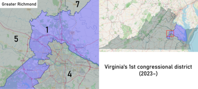
| Virginia's 1st congressional district | |
|---|---|
Interactive map of district boundaries since 2023 | |
| Representative | |
| Distribution |
|
| Population (2022) | 810,541[2] |
| Median household income | $99,057[3] |
| Ethnicity |
|
| Cook PVI | R+6[4] |

Virginia's first congressional district is a United States congressional district in the commonwealth of Virginia.
The district is sometimes referred to as "America's First District" since it includes the Historic Triangle of Jamestown, Williamsburg, and Yorktown. In the 18th and early 19th century, it comprised northwestern Virginia (that became Frederick County, Virginia as well as the Eastern Panhandle of West Virginia after the American Civil War). The district includes major military installations and has been represented by Republican Rob Wittman since 2007.
In 2016, the adjacent 3rd district was ruled unconstitutional. New districts have been drawn.[5][6]
- ^ "Congressional Districts Relationship Files (state-based)". www.census.gov. US Census Bureau Geography. Retrieved April 7, 2018.
- ^ "My Congressional District". www.census.gov. Center for New Media & Promotion (CNMP), US Census Bureau. Retrieved October 6, 2023.
- ^ "My Congressional District".
- ^ "2022 Cook PVI: District Map and List". Cook Political Report. July 12, 2022. Retrieved January 10, 2023.
- ^ "Virginia Politics: Court orders redistricting". Daily Press. Retrieved May 6, 2017.
- ^ Pathé, Simone (January 7, 2016). "Judges Select New Virginia Congressional Map". Rollcall.com. Retrieved October 30, 2022.
© MMXXIII Rich X Search. We shall prevail. All rights reserved. Rich X Search

