Back Waimakariri District CEB Waimakariri District German District du Waimakariri French Distretto del Waimakariri Italian Daerah Waimakariri Malay Waimakariri District NN ضلع وائیماکاریری PNB Уаимакарири (округ) Russian
Waimakariri District | |
|---|---|
 Council offices in Rangiora | |
 | |
| Coordinates: 43°18′S 172°18′E / 43.3°S 172.3°E | |
| Country | New Zealand |
| Island | South Island (Te Waipounamu) |
| Region | Canterbury |
| Communities |
|
| Wards |
|
| Named for | Waimakariri River |
| Seat | Rangiora |
| Towns | |
| Government | |
| • Mayor | Dan Gordon |
| • Deputy Mayor | Neville Atkinson |
| • Territorial authority | Waimakariri District Council |
| Area | |
| • Total | 2,217.12 km2 (856.03 sq mi) |
| Population (June 2023)[2] | |
| • Total | 69,000 |
| • Density | 31/km2 (81/sq mi) |
| Demonym | Waimakaririan [citation needed] |
| Time zone | UTC+12 (NZST) |
| • Summer (DST) | UTC+13 (NZDT) |
| Postcode(s) | |
| Area Code | 03 |
| Website | www |
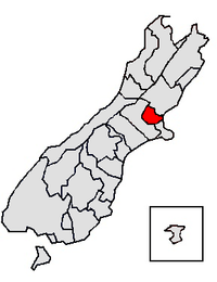
Waimakariri District is a local government district, located in the Canterbury Region of New Zealand's South Island. It is named after the Waimakariri River, which forms the district's southern boundary, separating it from Christchurch City and the Selwyn District. It is bounded in the north by the Hurunui District and in the east by the Pacific Ocean.
The district was established on 1 April 1989 following the merger of Rangiora District and Eyre County. The district covers 2,217.12 square kilometres (856.03 sq mi), and is home to 69,000 people.[2] Rangiora is the district seat and largest town, with other major towns including Kaiapoi, Oxford, Pegasus and Woodend.
The current district mayor is Dan Gordon, who was elected in the 2019 local body elections.[3]
- ^ Cite error: The named reference
Areawas invoked but never defined (see the help page). - ^ a b "Subnational population estimates (RC, SA2), by age and sex, at 30 June 1996-2023 (2023 boundaries)". Statistics New Zealand. Retrieved 25 October 2023. (regional councils); "Subnational population estimates (TA, SA2), by age and sex, at 30 June 1996-2023 (2023 boundaries)". Statistics New Zealand. Retrieved 25 October 2023. (territorial authorities); "Subnational population estimates (urban rural), by age and sex, at 30 June 1996-2023 (2023 boundaries)". Statistics New Zealand. Retrieved 25 October 2023. (urban areas)
- ^ "Waimakariri District Council 2019 Triennial Elections Declaration of Result" (PDF). Waimakariri District Council. Retrieved 7 November 2019.
© MMXXIII Rich X Search. We shall prevail. All rights reserved. Rich X Search
