Back جبهة دافئة Arabic Топъл атмосферен фронт Bulgarian Front càlid Catalan Teplá fronta Czech Varmfront Danish Warmfront German Frente cálido Spanish Soe front Estonian Fronte bero Basque جبهه گرم Persian


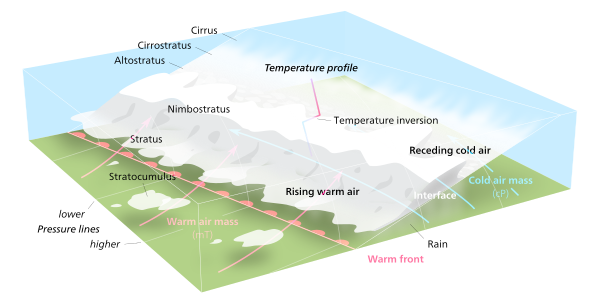
A warm front is a density discontinuity located at the leading edge of a homogeneous warm air mass, and is typically located on the equator-facing edge of an isotherm gradient. Warm fronts lie within broader troughs of low pressure than cold fronts, and move more slowly than the cold fronts which usually follow because cold air is denser and less easy to remove from the Earth's surface.[1] This also forces temperature differences across warm fronts to be broader in scale. Clouds ahead of the warm front are mostly stratiform, and rainfall generally increases as the front approaches. Fog can also occur preceding a warm frontal passage. Clearing and warming is usually rapid after frontal passage. If the warm air mass is unstable, thunderstorms may be embedded among the stratiform clouds ahead of the front, and after frontal passage thundershowers may continue. On weather maps, the surface location of a warm front is marked with a red line of semicircles pointing in the direction of travel.[1]
- ^ a b David Roth (2006-12-14). "Unified Surface Analysis Manual" (PDF). Hydrometeorological Prediction Center. Retrieved 2010-12-17.
© MMXXIII Rich X Search. We shall prevail. All rights reserved. Rich X Search