Back واترفورد، کانتیکت AZB Waterford (Connecticut) Catalan Вотерфорд (Коннектикут) CE Waterford (Connecticut) German Waterford (Connecticut) Spanish Waterford (Connecticut) Basque Waterford (Connecticut) French Waterford, Connecticut HT Waterford (Connecticut) Italian Ватерфорд (Коннектикут) Kazakh
This article needs additional citations for verification. (September 2011) |
Waterford, Connecticut | |
|---|---|
| Town of Waterford | |
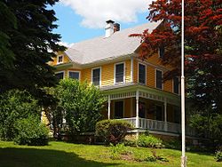
 A house in Quaker Hill | |
| Coordinates: 41°20′59″N 72°08′49″W / 41.34972°N 72.14694°W | |
| Country | |
| U.S. state | |
| County | New London |
| Region | Southeastern CT |
| Incorporated | 1801 |
| Government | |
| • Type | Representative town meeting |
| • First Selectman | Robert J. Brule (R)[1] |
| • Selectwoman | Jody Nazarchyk (R) |
| • Selectwoman | Elizabeth A. Sabilia (D) |
| • Town Clerk | David L. Campo (R) |
| Area | |
| • Total | 44.6 sq mi (115.4 km2) |
| • Land | 32.8 sq mi (84.9 km2) |
| • Water | 11.8 sq mi (30.5 km2) |
| Elevation | 46 ft (14 m) |
| Population (2020) | |
| • Total | 19,571 |
| • Density | 440/sq mi (170/km2) |
| Time zone | UTC−5 (Eastern) |
| • Summer (DST) | UTC−4 (Eastern) |
| ZIP Codes | 06375, 06385 |
| Area code(s) | 860/959 |
| FIPS code | 09-80280 |
| GNIS feature ID | 0213526 |
| Interstates | |
| List of auxiliary Interstate Highways | |
| U.S. Highways | |
| State Routes | |
| Website | www |
Waterford is a town in New London County, Connecticut. It is named after Waterford, Ireland. The town is part of the Southeastern Connecticut Planning Region. The population was 19,571 at the 2020 census.[2] The town center is listed as a census-designated place (CDP) and had a population of 3,074 at the 2020 census.[3]
- ^ "Elected Officials". Waterford CT. Retrieved September 16, 2015.
- ^ "Census - Geography Profile: Waterford town, New London County, Connecticut". United States Census Bureau. Retrieved December 22, 2021.
- ^ "Census - Geography Profile: Waterford CDP, Connecticut". United States Census Bureau. Retrieved December 22, 2021.
© MMXXIII Rich X Search. We shall prevail. All rights reserved. Rich X Search


