| West Branch Mohock Branch | |
|---|---|
 West Branch flowing under the Hamden Covered Bridge | |
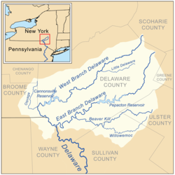
 Map of the upper Delaware River watershed, showing major tributaries | |
| Location | |
| Country | United States |
| State | New York |
| Region | Catskills |
| Counties | Schoharie, Delaware |
| Towns | Stamford, Delhi, Hancock, Deposit |
| Physical characteristics | |
| Source | Unnamed pond |
| • location | North of Mount Jefferson |
| • coordinates | 42°27′16″N 74°36′01″W / 42.45444°N 74.60028°W[1] |
| Mouth | Delaware River |
• location | Hancock |
• coordinates | 41°56′20″N 75°16′45″W / 41.9389755°N 75.2790615°W[1] |
• elevation | 883 ft (269 m)[1] |
| Length | 90 mi (140 km) |
| Basin size | 666 sq mi (1,720 km2)[2] |
| Discharge | |
| • location | Walton |
| • average | 469 cu ft (13.3 m3) |
| • minimum | 12 cu ft (0.34 m3) |
| • maximum | 28,600 cu ft (810 m3) |
| Discharge | |
| • location | Hale Eddy |
| • average | 780 cu ft (22 m3) |
| • minimum | 17 cu ft (0.48 m3) |
| • maximum | 43,400 cu ft (1,230 m3) |
| Basin features | |
| River system | Delaware River |
| Tributaries | |
| • left | Little Delaware River |
| • right | West Brook, Oquaga Creek |
The West Branch Delaware River is one of two branches that form the Delaware River. It is approximately 90 mi (144 km) long, and flows through the U.S. states of New York and Pennsylvania. It winds through a mountainous area of New York in the western Catskill Mountains for most of its course, before joining the East Branch along the northeast border of Pennsylvania with New York.[2] Midway or so it is empounded by the Cannonsville Dam to form the Cannonsville Reservoir, both part of the New York City water supply system for delivering drinking water to the City.[3][4]
- ^ a b c "West Branch Delaware River". Geographic Names Information System. United States Geological Survey, United States Department of the Interior. Retrieved 2019-05-24.
- ^ a b "USGS 0142712905 W BR DELAWARE RIVER AT MOUTH AT HANCOCK PA". usgs.gov. usgs. 2019. Retrieved 24 May 2019.
data
- ^ "Cannonsville Reservoir". Geographic Names Information System. United States Geological Survey, United States Department of the Interior. Retrieved 2018-09-23.
- ^ "Cannonsville Dam". Geographic Names Information System. United States Geological Survey, United States Department of the Interior. Retrieved 2018-09-23.
© MMXXIII Rich X Search. We shall prevail. All rights reserved. Rich X Search
