This article has multiple issues. Please help improve it or discuss these issues on the talk page. (Learn how and when to remove these template messages)
|
West Coast Highway | |
|---|---|
 | |
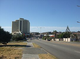
| View northbound approaching Scarborough | |
 | |
| General information | |
| Type | Highway |
| Length | 13 km (8.1 mi) |
| Opened | 1960s |
| Route number(s) | |
| Tourist routes | |
| Major junctions | |
| South end | |
| |
| North end | |
| Location(s) | |
| Major suburbs | City Beach, Scarborough |
| Highway system | |
| ---- | |
West Coast Highway is an arterial coastal highway located in the western and inner northern suburbs of Perth, Western Australia. It is part of State Route 71, and also Tourist Drive 204 in various coastal parts.[1]
The highway commences from the end of Curtin Avenue at Swanbourne and heads north, via the SAS Campbell Barracks and rifle range, to City Beach, Scarborough and Trigg, terminating at the Karrinyup Road intersection, where it becomes Marmion Avenue. It links the northern coastal suburbs of Perth with the city of Fremantle. The speed limit for the majority of the highway is 70 km/h with two small 60 and 80 km/h sections at the Scarborough end. The highway is a dual carriageway for most of its length.
- ^ Distance book (12 ed.). Main Roads Western Australia. 2012. pp. 4–5. ISBN 978-0-7309-7657-8. Retrieved 3 January 2014.
© MMXXIII Rich X Search. We shall prevail. All rights reserved. Rich X Search
