Back ويست سانت بول Arabic ويسانت سانت بول ARZ وست سنت پاول، مینهسوتا AZB Вест-Сент-Пол (Миннесота) CE West Saint Paul CEB West St. Paul German West St. Paul (Minnesota) Spanish West St. Paul (Minnesota) Basque وست سنت پاول، مینهسوتا Persian West Saint Paul (Minnesota) French
West St. Paul | |
|---|---|
| City of West St. Paul | |
 | |
| Nickname: W.S.P. | |
| Motto: "We're Close To It All" | |
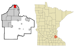
 Location of the city of West St. Paul within Dakota County, Minnesota | |
| Coordinates: 44°54′58″N 93°06′06″W / 44.91611°N 93.10167°W | |
| Country | United States |
| State | Minnesota |
| County | Dakota |
| Founded | 1858 |
| Incorporated | February 23, 1889 |
| Government | |
| • Mayor | Dave Napier |
| Area | |
| • Total | 5.01 sq mi (12.98 km2) |
| • Land | 4.91 sq mi (12.71 km2) |
| • Water | 0.10 sq mi (0.27 km2) |
| Elevation | 1,027 ft (313 m) |
| Population | |
| • Total | 20,615 |
| • Estimate (2022)[4] | 21,794 |
| • Density | 4,200.29/sq mi (1,621.70/km2) |
| Time zone | UTC-6 (Central (CST)) |
| • Summer (DST) | UTC-5 (CDT) |
| ZIP code | 55118 |
| Area code | 651 |
| FIPS code | 27-69700 |
| GNIS feature ID | 654003[2] |
| Sales tax | 8.625%[5] |
| Website | wspmn.gov |
West St. Paul is a city in Dakota County, Minnesota, United States. The population was 20,615 at the 2020 census.[3] It is immediately south of Saint Paul and immediately west of South St. Paul.
- ^ "2020 U.S. Gazetteer Files". United States Census Bureau. Retrieved July 24, 2022.
- ^ a b U.S. Geological Survey Geographic Names Information System: West St. Paul, Minnesota
- ^ a b "Explore Census Data". United States Census Bureau. Retrieved June 17, 2022.
- ^ Cite error: The named reference
USCensusEst2022was invoked but never defined (see the help page). - ^ "West Saint Paul (MN) sales tax rate". Retrieved December 31, 2023.
© MMXXIII Rich X Search. We shall prevail. All rights reserved. Rich X Search