Back جبال وايت Arabic جبال وايت ARZ Уайт-Маўнтынс (Нью-Гэмпшыр) Byelorussian Montagnes Blanches (bukid) CEB White Mountains (New Hampshire) Czech White Mountains (New Hampshire) German Montañas Blancas (Nuevo Hampshire) Spanish Mendi Zuriak (New Hampshire) Basque Montagnes Blanches (Appalaches) French ホワイト山地 (ニューハンプシャー州) Japanese
| White Mountains | |
|---|---|
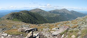
 From left to right: Mount Clay, Mount Jefferson, Mount Adams, and Mount Madison viewed from Mount Washington | |
| Highest point | |
| Peak | Mount Washington |
| Elevation | 6,288 ft (1,917 m) |
| Coordinates | 44°16′15″N 71°18′12.5″W / 44.27083°N 71.303472°W |
| Geography | |
| Country | United States |
| States | New Hampshire and Maine |
| Region | New England |
| Range coordinates | 44°16′16″N 71°18′18″W / 44.271°N 71.305°W |
| Parent range | Appalachian Mountains |
The White Mountains are a mountain range covering about a quarter of the state of New Hampshire and a small portion of western Maine in the United States. They are a subrange of the northern Appalachian Mountains and the most rugged mountains in New England. Several of the higher peaks contain an Alpine tundra. The range is heavily visited due to its proximity to Boston, New York City, and Montreal.
Most of the area is public land, including the White Mountain National Forest and a number of state parks. Its most famous mountain is 6,288-foot (1,917 m) Mount Washington, which is the highest peak in the Northeastern U.S. and for 76 years held the record for fastest surface wind gust in the world (231 miles per hour (372 km/h) in 1934). Mount Washington is part of a line of summits, the Presidential Range, that are named after U.S. presidents and other prominent Americans.
The White Mountains also include the Franconia Range, Sandwich Range, Carter-Moriah Range and Kinsman Range in New Hampshire, and the Mahoosuc Range straddling the border between it and Maine. In all, there are 48 peaks within New Hampshire as well as one (Old Speck Mountain) in Maine over 4,000 feet (1,200 m), known as the four-thousand footers.
The Whites are known for a system of alpine huts for hikers operated by the Appalachian Mountain Club. The Appalachian Trail crosses the area from southwest to northeast.
© MMXXIII Rich X Search. We shall prevail. All rights reserved. Rich X Search
