This article needs additional citations for verification. (August 2012) |
| Windpark Noordoostpolder | |
|---|---|
 | |
 | |
| Country | Netherlands |
| Location | IJsselmeer, North East Polder, Flevoland |
| Coordinates | 52°43′16″N 5°34′59″E / 52.721°N 5.583°E |
| Status | Operational |
| Construction began | 2012 |
| Commission date | 2017 |
| Construction cost | 1 billion euros |
| Owner(s) | Koepel Windenergie Nordoostpolder and Innogy |
| Wind farm | |
| Type | Near-shore (Siemens) Onshore (Enercon) |
| Max. water depth | 3–6 m (10–20 ft) |
| Distance from shore | 0.5 km (0.3 mi) |
| Site area | 8 km2 (3.1 sq mi) |
| Power generation | |
| Units operational | 48 x 3 MW (near-shore) 38 x 7.5 MW (onshore) 86 turbines in total |
| Make and model | Siemens Wind Power: 3.0DD-108 Enercon: E-126 |
| Nameplate capacity | 429 MW |
| External links | |
| Commons | Related media on Commons |
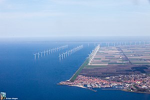
Windpark Noordoostpolder is an onshore and near-shore wind farm in Flevoland, the Netherlands. Upon completion in 2017, it was the largest wind farm in the Netherlands, and as of 2019 it is still one of the largest. Owner-operators are members of the Koepel Windenergie Noordoostpolder, a partnership of more than 100 agricultural entrepreneurs from the North East Polder (Noordoostpolder), and Innogy, a subsidiary of German energy company RWE.[1]
© MMXXIII Rich X Search. We shall prevail. All rights reserved. Rich X Search
