Back ويفينهو ARZ Lake Wivenhoe (tubiganan) CEB Lake Wivenhoe German Lake Wivenhoe Swedish Wivenhoe to'g'oni Uzbek
| Wivenhoe Dam | |
|---|---|
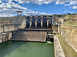
 The Wivenhoe Dam wall and spillway | |
Location of the Wivenhoe Dam in Queensland | |
| Country | Australia |
| Location | South East Queensland |
| Coordinates | 27°23′38″S 152°36′28″E / 27.39389°S 152.60778°E |
| Purpose | |
| Status | Operational |
| Construction began | March 1973 |
| Opening date | 1984 |
| Operator(s) | SEQ Water |
| Dam and spillways | |
| Type of dam | Embankment dam |
| Impounds | Brisbane River |
| Height | 59 m (194 ft) |
| Height (thalweg) | 23 m (75 ft) AHD |
| Length | 2,300 m (7,500 ft) |
| Elevation at crest | 79 m (259 ft) AHD |
| Dam volume | 4,140×103 m3 (146×106 cu ft) |
| Spillways | 2 |
| Spillway type |
|
| Spillway capacity | 12,000 m3/s (420,000 cu ft/s) |
| Reservoir | |
| Creates | Wivenhoe Reservoir |
| Total capacity | 1,165,238 ML (256,317×106 imp gal; 307,823×106 US gal) |
| Catchment area | 7,020 km2 (2,710 sq mi) |
| Surface area | 109.4 km2 (42.2 sq mi) |
| Wivenhoe Power Station | |
| Operator(s) | Tarong Energy |
| Commission date | May 1984 |
| Type | Pumped-storage |
| Turbines | 2 |
| Installed capacity | 500 MW (670,000 hp) |
| Website www.seqwater.com.au | |
The Wivenhoe Dam is a rock and earth-fill embankment dam with a concrete spillway across the Brisbane River in South East Queensland, Australia. The dam takes it names from the local Wivenhoe Pocket rural community. The dam wall is located about 80 kilometres (50 mi) by road from the centre of Brisbane. The primary purpose of the dam is the supply of potable water for the Brisbane and Ipswich regions. The dam also provides for flood mitigation control, hydroelectricity, and recreation.[1] The impounded reservoir is called Lake Wivenhoe and the dam, the lake and a narrow strip of surrounding land forms a locality also called Lake Wivenhoe.
Wivenhoe Dam was planned in the early 1970s. The 1974 Brisbane flood highlighted the need for flood protection for South East Queensland.[2] The lake also forms part of the water storages for the Wivenhoe Power Station.
- ^ a b "Register of Large Dams in Australia". Dams information. Australian National Committee on Large Dams. 2010. Archived from the original (Excel (requires download)) on 12 December 2013. Retrieved 5 July 2014.
- ^ "Wivenhoe and Somerset Dams" (PDF). SEQ Water Grid. The Queensland Cabinet and Ministerial Directory. Retrieved 13 January 2011.
© MMXXIII Rich X Search. We shall prevail. All rights reserved. Rich X Search
