Back فوردن Arabic فوردن ARZ Woerden Breton Woerden Catalan Gemeente Woerden CEB Woerden German Woerden Esperanto Woerden Spanish Woerden Basque ووردن Persian
Woerden | |
|---|---|
City and Municipality | |
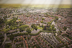
 Aerial view of Woerden in 2013 | |
 Location in Utrecht | |
| Coordinates: 52°5′N 4°53′E / 52.083°N 4.883°E | |
| Country | Netherlands |
| Province | Utrecht |
| Government | |
| • Body | Municipal council |
| • Mayor | Victor Molkenboer (PvdA) |
| Area | |
| • Total | 92.92 km2 (35.88 sq mi) |
| • Land | 88.57 km2 (34.20 sq mi) |
| • Water | 4.35 km2 (1.68 sq mi) |
| Elevation | 0 m (0 ft) |
| Population (January 2021)[4] | |
| • Total | 52,694 |
| • Density | 595/km2 (1,540/sq mi) |
| Demonym | Woerdenaar |
| Time zone | UTC+1 (CET) |
| • Summer (DST) | UTC+2 (CEST) |
| Postcode | 3440–3449, 3470–3481 |
| Area code | 0348 |
| Website | www |

Woerden (Dutch pronunciation: [ˈʋuːrdə(n)] ) is a city and a municipality in central Netherlands. Due to its central location between Amsterdam, Rotterdam, The Hague, and Utrecht, and the fact that it has rail and road connections to those cities, it is a popular town for commuters who work in those cities.
- ^ "Burgemeester V.J.H. (Victor) Molkenboer" [Mayor V.J.H. (Victor) Molkenboer] (in Dutch). Gemeente Woerden. Retrieved 11 April 2014.
- ^ "Kerncijfers wijken en buurten 2020" [Key figures for neighbourhoods 2020]. StatLine (in Dutch). CBS. 24 July 2020. Retrieved 19 September 2020.
- ^ "Postcodetool for 3447GR". Actueel Hoogtebestand Nederland (in Dutch). Het Waterschapshuis. Retrieved 11 April 2014.
- ^ "Bevolkingsontwikkeling; regio per maand" [Population growth; regions per month]. CBS Statline (in Dutch). CBS. 1 January 2021. Retrieved 2 January 2022.
© MMXXIII Rich X Search. We shall prevail. All rights reserved. Rich X Search

