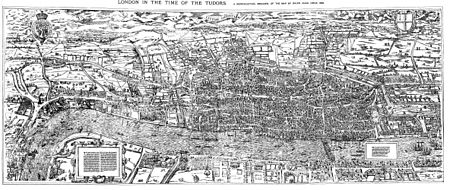
The "Woodcut" map of London, formally titled Civitas Londinum, and often referred to as the "Agas" map of London, is one of the earliest true maps (as opposed to panoramic views, such as those of Anton van den Wyngaerde) of the City of London and its environs. The original map probably dated from the early 1560s, but it survives only in later and slightly modified copies. It was printed from woodcut blocks on eight sheets, and in its present state measures approximately 2 feet 4 inches (71 cm) high by 6 feet (180 cm) wide. There has been some damage to the blocks, and it was probably originally fractionally larger.[1]
The Woodcut map is a slightly smaller-scale, cruder and lightly modified copy of the so-called "Copperplate" map, surveyed between 1553 and 1559, which, however, survives only in part. It also bears a close resemblance to the map of London included in Georg Braun and Frans Hogenberg's Civitates Orbis Terrarum, published in Cologne and Amsterdam in 1572, although this is on a greatly reduced scale.[2]
The Woodcut map was traditionally attributed to the surveyor and cartographer Ralph Agas, but this attribution is now considered to be erroneous.
- ^ Marks 1964, p. 15
- ^ Reproduced in Prockter, Taylor & Fisher 1979, p. 32
© MMXXIII Rich X Search. We shall prevail. All rights reserved. Rich X Search
