Back Wotton (parokya) CEB Wotton (Surrey) French Wotton LLD Wotton Dutch Wotton (Surrey) Polish Wotton, Surrey Swedish Wotton, Surrey Turkish Wotton ZH-MIN-NAN
| Wotton | |
|---|---|
 Waterfall, Upper Tilling Valley | |
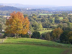
 View towards Dorking, the Cotmandene (right), Box Hill and the Botley Hill escarpment of the North Downs (left) from part of Wotton. This shows how the centre of Wotton is in a narrow part of the 'Vale of Holmesdale' which is not a single vale. | |
Location within Surrey | |
| Area | 22.43 km2 (8.66 sq mi) |
| Population | 583 (Civil Parish 2011 including Friday Street)[1] |
| • Density | 26/km2 (67/sq mi) |
| OS grid reference | TQ1348 |
| Civil parish |
|
| District | |
| Shire county | |
| Region | |
| Country | England |
| Sovereign state | United Kingdom |
| Post town | Dorking |
| Postcode district | RH5 |
| Dialling code | 01306 |
| Police | Surrey |
| Fire | Surrey |
| Ambulance | South East Coast |
| UK Parliament | |
Wotton /ˈwʊtən/ is a well-wooded parish with one main settlement, a small village mostly south of the A25 between Guildford in the west and Dorking in the east. The nearest village with a small number of shops is Westcott. Wotton lies in a narrow valley, collecting the headwaters of the Tilling Bourne which then has its first combined flow in the Vale of Holmesdale. The parish is long north to south, reaching to the North Downs escarpment (and the North Downs Way) in the north to the escarpment of the Greensand Ridge at Leith Hill in the south.
Wotton Common forming the south of the parish is elevated woodland dotted with a few vernacular-style houses and has the county's only natural waterfall. The common's main settlement is Friday Street.
- ^ Key Statistics; Quick Statistics: Population Density United Kingdom Census 2011 Office for National Statistics Retrieved 21 November 2013
© MMXXIII Rich X Search. We shall prevail. All rights reserved. Rich X Search
