Back Wufeng Tujiazu Zizhixian CEB Wufeng (Yichang) German Wufeng (Yichang) Spanish Xian autonome tujia de Wufeng French Contea autonoma tujia di Wufeng Italian 五峰トゥチャ族自治県 Japanese 우펑 투자족 자치현 Korean Wufeng NB Wufeng (Yichang) Polish Уфэн-Туцзяский автономный уезд Russian
Wufeng County
五峰县 | |
|---|---|
| 五峰土家族自治县 Wufeng Tujia Autonomous County | |
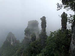
 Wufeng Chai Buxi Grand Canyon Scenic Spot | |
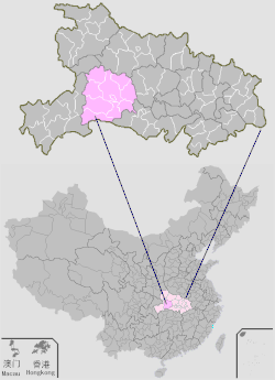
 Wufeng is the southernmost division on this map of Yichang | |
 Yichang in Hubei | |
| Coordinates: 30°09′25″N 111°04′26″E / 30.157°N 111.074°E | |
| Country | People's Republic of China |
| Province | Hubei |
| Prefecture-level city | Yichang |
| Area | |
| • Total | 2,401 km2 (927 sq mi) |
| Population (2010)[1] | |
| • Total | 188,923 |
| • Density | 79/km2 (200/sq mi) |
| Time zone | UTC+8 (China Standard) |
| Website | www |
Wufeng Tujia Autonomous County (simplified Chinese: 五峰土家族自治县; traditional Chinese: 五峯土家族自治縣; pinyin: Wǔfēng Tǔjiāzú Zìzhìxiàn), formerly Changle County (Changlo County 長樂縣),[1] is a county in the west of Hubei province, People's Republic of China, bordering Hunan province to the south. It is under the administration of the prefecture-level city of Yichang. It is twinned with Westfield, Massachusetts, United States.[citation needed]
© MMXXIII Rich X Search. We shall prevail. All rights reserved. Rich X Search