Back وايومنغ (ميشيغان) Arabic وايومنج (كينت) ARZ ویومینق، میشیقان AZB Вайоминг (Мичиган) CE Wyoming (lungsod sa Tinipong Bansa, Michigan) CEB Wyoming, Michigan Welsh Wyoming (Michigan) German Wyoming (Míchigan) Spanish Wyoming (Michigan) Basque ویومینگ، میشیگان Persian
Wyoming, Michigan | |
|---|---|
From top, left to right: Wyoming City Hall. Water tower near Gezon Park in Wyoming's panhandle. Panoramic view east down 28th Street, the city's main commercial route. | |
| Motto(s): City of Vision and Progress | |
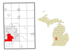
 Location within Kent County | |
| Coordinates: 42°52′35″N 85°45′27″W / 42.87639°N 85.75750°W | |
| Country | United States |
| State | Michigan |
| County | Kent |
| Organized | 1848 (Wyoming Township) |
| Incorporated | 1959 |
| Government | |
| • Type | Mayor–council |
| • Mayor | Kent Vanderwood |
| • Manager | Curtis Holt |
| • Clerk | Kelli VandenBerg |
| Area | |
| • Total | 24.95 sq mi (64.62 km2) |
| • Land | 24.74 sq mi (64.08 km2) |
| • Water | 0.21 sq mi (0.54 km2) |
| Elevation | 666 ft (203 m) |
| Population (2020) | |
| • Total | 76,501 |
| • Density | 3,092.07/sq mi (1,193.84/km2) |
| Time zone | UTC-5 (EST) |
| • Summer (DST) | UTC-4 (EDT) |
| ZIP code(s) | |
| Area code | 616 |
| FIPS code | 26-88940[3] |
| GNIS feature ID | 1627295[2] |
| Website | Official website |
Wyoming is a city in Kent County in the U.S. state of Michigan. The population was 76,501 at the 2020 census.[4] Wyoming is the second most-populated community in the Grand Rapids metropolitan area and is bordered by Grand Rapids on the northeast. After Grand Rapids, it is also the second most-populated city in West Michigan.
The area was the second location in Kent County settled by European-Americans in 1832 on the edges of Buck Creek and was organized as Wyoming Township in 1848 when it was set off from the northern half of Byron Township. Through the 1800s and into the early 1900s, Wyoming served as a rural area providing goods to Grand Rapids, though with the introduction of the Grand Rapids, Holland and Chicago Railway, the township experienced suburbanization. After Grandville separated from the township in 1933 and Wyoming experienced more growth with the opening of the General Motors Stamping Division Plant, Wyoming was engaged in annexation conflicts with Grand Rapids and Grandville until the township became incorporated as the city of Wyoming in 1959.
After obtaining cityhood, Wyoming served as an entertainment and retail destination on the 28th Street corridor with the opening of Rogers Plaza and Studio 28. Into the 1980s, the quality of development in Wyoming began to falter and with the 1999 opening of RiverTown Crossings in Grandville, retail businesses in the city were upended. Development in Wyoming then shifted towards the southwest panhandle near RiverTown Crossings in the early 21st century and has continued in the area surrounding Metro Health Hospital following its opening in 2007, though General Motors closed the stamping plant two years later in 2009. Since the mid-2010s, the city has focused on redeveloping its center on 28th Street with the 28 West project as well as the 74 acres (300,000 m2) of former General Motors land, now known as Site 36.
- ^ "2020 U.S. Gazetteer Files". United States Census Bureau. Retrieved May 21, 2022.
- ^ a b U.S. Geological Survey Geographic Names Information System: Wyoming, Michigan
- ^ "U.S. Census website". United States Census Bureau. Retrieved January 31, 2008.
- ^ "Wyoming city, Michigan". United States Census Bureau. Retrieved April 15, 2022.
© MMXXIII Rich X Search. We shall prevail. All rights reserved. Rich X Search


