Back شین چایی AZB Синдзян (река) Bulgarian Sin-ťiang (přítok jezera Pcho-jang) Czech Río Xin Spanish 信江 Japanese Xinfloden Swedish Сіньцзян (річка) Ukrainian 信江 Chinese
| Xin | |
|---|---|
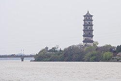
 Kuiwen Pagoda and Xin River in Shangrao | |
| Native name | 信江 (Chinese) |
| Location | |
| Country | China |
| Region | Jiangxi Province |
| City | Shangrao, Yingtan |
| Physical characteristics | |
| Source | Yushan River |
| • location | Huaiyu Mountains, Sanqing, Yushan |
| • coordinates | 28°59′N 118°05′E / 28.983°N 118.083°E |
| 2nd source | Feng River |
| • location | Tongbo Mountain, Pucheng |
| 3rd source | |
| • location | Xinzhou District, Shangrao |
| • coordinates | 28°26′24″N 117°57′40″E / 28.44000°N 117.96111°E |
| Mouth | |
• location | Yugan |
• coordinates | 28°36′40″N 116°40′35″E / 28.61111°N 116.67639°E |
| Length | 360.5 km (224.0 mi) |
| Basin size | 17,600 km2 (6,800 sq mi) |
| Basin features | |
| River system | Yangtze River-Poyang Lake |
The Xin River (Chinese: 信江; pinyin: Xīn Jiāng; Wade–Giles: Hsin Jiang) flows in Yushan County from the eastern edge of Jiangxi Province of central China into Poyang Lake.[1][2][3][4] Some Wikipedia maps appear to call this the Xiao River.
- ^ 2010. The New Encyclopædia Britannica. Encyclopædia Britannica, Chicago, US. Vol. 6, p. 101.
- ^ 2007. Oxford Atlas of the World. Oxford University Press, Inc., New York, New York, US.
- ^ 2005. National Geographic Atlas of the World. 8th ed. National Geographic. Washington, DC.
- ^ 2003. Hammond World Atlas. Hammond World Atlas Corp. Italy.
© MMXXIII Rich X Search. We shall prevail. All rights reserved. Rich X Search