Back Estructures de Yonaguni AST Подводен монумент Йонагуни Bulgarian Estructures de Yonaguni Catalan Yonaguni-formationen Danish Yonaguni-Monument German Estructuras de Yonaguni Spanish Yonaguniko Egiturak Basque Structure sous-marine de Yonaguni French Monumen Yonaguni ID Struttura Yonaguni Italian
Yonaguni Monument
Yonaguni Submarine Topography | |
|---|---|
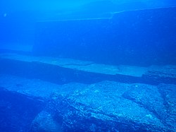
 Yonaguni Monument, as seen from the south of the formation. | |
| Coordinates: 24°26′09″N 123°00′41″E / 24.435833°N 123.011389°E | |
| Location | |
| Offshore water bodies | Philippine Sea |
| Dimensions | |
| • Depth | 26 m (85 ft) |
The Yonaguni Monument (Japanese: 与那国島海底地形, Hepburn: Yonaguni-jima Kaitei Chikei, lit. "Yonaguni Island Submarine Topography"), also known as "Yonaguni (Island) Submarine Ruins" (与那国(島)海底遺跡, Yonaguni(-jima) Kaitei Iseki), is a submerged rock formation off the coast of Yonaguni, the southernmost of the Ryukyu Islands, in Japan. It lies approximately 100 kilometres (54 nmi; 62 mi) east of Taiwan.
Marine geologist Masaaki Kimura claims that the formations are man-made stepped monoliths.[1] These claims have been described as pseudoarchaeological.[2] Neither the Japanese Agency for Cultural Affairs nor the government of Okinawa Prefecture recognise the features as important cultural artifacts and neither government agency has carried out research or preservation work on the site.[3]
- ^ "Deep Secrets". New Scientist. Vol. 204, Issue 2736. 28 November 2009. p. 41.
- ^ Feagans, Carl (October 16, 2017). "Yonaguni: Monumental Ruins or Natural Geology?". Archaeology Review.
- ^ Ryall, Julian (September 19, 2007). "Japan's Ancient Underwater "Pyramid" Mystifies Scholars". National Geographic News. Archived from the original on August 7, 2019.
© MMXXIII Rich X Search. We shall prevail. All rights reserved. Rich X Search
