Back یونا چایی AZB Río Yuna CEB Юна (юханшыв) CV Río Yuna German Río Yuna Spanish Yuna (fleuve) French Rio Yuna Croatian Juna Lithuanian Yuna (rivier) Dutch Юна (река, впадает в залив Самана) Russian
| Yuna River Río Yuna | |
|---|---|
 | |
 Map showing the Yuna drainage basin | |
| Location | |
| Country | |
| Provinces | Monseñor Nouel, Sánchez Ramírez, Duarte, Samaná |
| Cities | Bonao, Cotuí |
| Physical characteristics | |
| Source | Cerro Montoso Hill |
| • location | La Cuesta de la Vaca, Bonao, Monseñor Nouel, Dominican Republic |
| • coordinates | 18°47′16″N 70°25′05″W / 18.78778°N 70.41806°W |
| • elevation | 1,075 m (3,527 ft) |
| Mouth | Samaná Bay |
• location | Los Haitises National Park, Sánchez, Samaná, Dominican Republic |
• coordinates | 19°11′47″N 69°37′24″W / 19.19639°N 69.62333°W |
• elevation | 0 m (0 ft) |
| Length | 185.17 km (115.06 mi)[1] |
| Basin size | 5,498 km2 (2,123 sq mi)[2] |
| Basin features | |
| Tributaries | |
| • left | Tireo River, Masipedro River, Yujo River, Camú River, Cuaba River, Nigua River, Yaiba River, Baiguate River, Azucey River, Guayabo River |
| • right | Yuboa River, Maimón River, Maguaca River, Chacuey River, Payabo River |
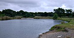
The Yuna River (Spanish: Río Yuna) is the second longest river in the Dominican Republic, stretching for a length of 185.17 km (115.06 miles). It forms within the Cordillera Central mountain range southwest of the city of Bonao in Monseñor Nouel Province, and passes through the fertile Cibao Valley.[3] As the river courses north-northeast, it passes through the city of Bonao. Southwest of Cotuí, the river reaches Hatillo Dam (Spanish: Presa de Hatillo) before turning northeast then east as it reaches its mouth at the Samaná Bay in the northeast part of the Dominican Republic.[4] Like many rivers in the Dominican Republic, the name is derived from the Taíno language.[5]
- ^ "Yuna River course (length plotted using My Places Editor)". Bing Maps. Retrieved 2012-08-09.
- ^ De la Fuente, Santiago (1976). Geografía Dominicana. Santo Domingo, Dominican Republic: Editora Colegial Quisqueyana. pp. 110–114.
- ^ Harvey, Sean (2011). The Rough Guide to the Dominican Republic. Penguin. p. 284. ISBN 9781405389112. Retrieved 2012-08-19.
ecosystem yuna river.
- ^ Google (2012-08-09). "Yuna River Mouth" (Map). Google Maps. Google. Retrieved 2012-08-09.
- ^ Cassá, Roberto (1992). Indians of the Antilles (Illustrated ed.). Editorial Abya Yala. p. 310. ISBN 9788471003751. Retrieved 2012-08-17.
© MMXXIII Rich X Search. We shall prevail. All rights reserved. Rich X Search