Back زافينتيم Arabic Завентем Bulgarian Zaventem Breton Zaventem Catalan Zaventem (parokya) CEB Zaventem German Zaventem Esperanto Zaventem Spanish Zaventem Basque زوانتم Persian
Zaventem | |
|---|---|
 | |
| Coordinates: 50°52′N 04°28′E / 50.867°N 4.467°E | |
| Country | |
| Community | Flemish Community |
| Region | Flemish Region |
| Province | Flemish Brabant |
| Arrondissement | Halle-Vilvoorde |
| Government | |
| • Mayor | Ingrid Holemans (Open Vld) |
| • Governing party/ies | Open Vld, CD&V |
| Area | |
| • Total | 27.73 km2 (10.71 sq mi) |
| Population (2021-01-01)[1] | |
| • Total | 35,184 |
| • Density | 1,300/km2 (3,300/sq mi) |
| Postal codes | 1930, 1932, 1933 |
| NIS code | 23094 |
| Area codes | 02 |
| Website | www.zaventem.be |
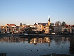
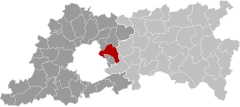
Zaventem (Dutch pronunciation: [ˈzaːvəntɛm]) is a municipality in the province of Flemish Brabant, in the Flemish region of Belgium. It is located in the Dijleland area, one of the three large recreational areas which together form the Groene Gordel ("Green Belt") around the Brussels-Capital Region. The municipality comprises the subdivisions or deelgemeenten of Nossegem, Sint-Stevens-Woluwe, Sterrebeek and Zaventem proper.
On 1 January 2006, Zaventem had a total population of 28,651. The total area is 27.62 km2 (10.66 sq mi), which gives a population density of 1,037/km2 (2,690/sq mi). The official language of Zaventem is Dutch. Zaventem is the home of Brussels Airport, together with neighbouring town of Diegem.
© MMXXIII Rich X Search. We shall prevail. All rights reserved. Rich X Search


