Zir'in
زرعين Zer'en | |
|---|---|
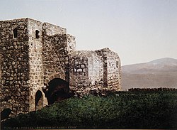
 The Tower House of Zir'in, by Felix Bonfils, before 1885. | |
A series of historical maps of the area around Zir'in (click the buttons) | |
Location within Mandatory Palestine | |
| Coordinates: 32°33′27″N 35°19′40″E / 32.55750°N 35.32778°E | |
| Palestine grid | 181/218 |
| Geopolitical entity | Mandatory Palestine |
| Subdistrict | Jenin |
| Date of depopulation | May 28, 1948[1] |
| Area | |
| • Total | 23,920 dunams (23.92 km2 or 9.24 sq mi) |
| Population (1945) | |
| • Total | 1,420 |
| Cause(s) of depopulation | Military assault by Yishuv forces |
| Current Localities | Yizre'el,[2] Avital[2] |
Zir'in (Arabic: زرعين, also spelled Zerein) was a Palestinian Arab village of over 1,400 in the Jezreel Valley, located 11 kilometers (6.8 mi) north of Jenin. Identified as the ancient town of Yizre'el (Jezreel), it was known as Zir'in during Islamic rule, and was near the site of the Battle of Ain Jalut, in which the Mamluks halted Mongol expansion southward. Under the Ottomans, it was a small village, expanding during the British Mandate in the early 20th century. After its capture by Israel in 1948, Zir'in was destroyed. The Israeli kibbutz of Yizre'el was established shortly after on the village lands of Zir'in.
© MMXXIII Rich X Search. We shall prevail. All rights reserved. Rich X Search


