Back Zwijndrecht, Nederland Afrikaans زفايندريخت Arabic Zwijndrecht (Països Baixos) Catalan Gemeente Zwijndrecht CEB Zwijndrecht (Niederlande) German Zwijndrecht (Nederlando) Esperanto Zwijndrecht (Países Bajos) Spanish Zwijndrecht (Herbehereak) Basque زوویندرخت (هلند) Persian Zwijndrecht (Alankomaat) Finnish
Zwijndrecht | |
|---|---|
 Zwijndrecht across the Oude Maas | |
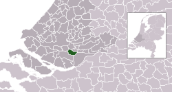
 Location in South Holland | |
| Coordinates: 51°49′N 4°39′E / 51.817°N 4.650°E | |
| Country | Netherlands |
| Province | South Holland |
| Government | |
| • Body | Municipal council |
| • Mayor | Dominic Schrijer (PvdA) |
| Area | |
| • Total | 22.77 km2 (8.79 sq mi) |
| • Land | 20.30 km2 (7.84 sq mi) |
| • Water | 2.47 km2 (0.95 sq mi) |
| Elevation | −1 m (−3 ft) |
| Population (January 2021)[4] | |
| • Total | 44,775 |
| • Density | 2,206/km2 (5,710/sq mi) |
| Demonym | Zwijndrechter |
| Time zone | UTC+1 (CET) |
| • Summer (DST) | UTC+2 (CEST) |
| Postcode | 3330–3336 |
| Area code | 078 |
| Website | www |


Zwijndrecht (Dutch pronunciation: [ˈzʋɛindrɛxt] ) is a town and municipality in the western Netherlands. It is in the province of South Holland, at the southern tip of the island of IJsselmonde, and at the confluence of the rivers Oude Maas, Beneden-Merwede, and Noord.
- ^ "Samenstelling college: Collegeperiode 2010–2014" [Members of the board: 2010–2014] (in Dutch). Gemeente Zwijndrecht. Retrieved 31 August 2013.
- ^ "Kerncijfers wijken en buurten 2020" [Key figures for neighbourhoods 2020]. StatLine (in Dutch). CBS. 24 July 2020. Retrieved 19 September 2020.
- ^ "Postcodetool for 3331BT". Actueel Hoogtebestand Nederland (in Dutch). Het Waterschapshuis. Retrieved 31 August 2013.
- ^ "Bevolkingsontwikkeling; regio per maand" [Population growth; regions per month]. CBS Statline (in Dutch). CBS. 1 January 2021. Retrieved 2 January 2022.
© MMXXIII Rich X Search. We shall prevail. All rights reserved. Rich X Search

