Back Maxvorstadt AN Maxvorstod BAR Maxvorstadt German Maxvorstadt English Maxvorstadt French מקספורשטאדט HE Maxvorstadt Interlingue Maxvorstadt Italian Maxvorstadt Latin Maxvorstadt Dutch
| Maxvorstadt | ||
|---|---|---|
| Entidad subnacional | ||
 | ||
 | ||
| Coordenadas | 48°09′00″N 11°34′10″E / 48.15, 11.569444444444 | |
| Entidad | Distrito de Múnich, Alemania y Barrio | |
| • País |
| |
| Superficie | ||
| • Total | 4,3 km² | |
| Población (2016) | ||
| • Total | 53 443 hab. | |
| • Densidad | 12 428,6 hab./km² | |
| Código postal | 80333, 80335, 80539, 80636 y 80797 | |
| Prefijo telefónico | 089 | |
| y https://stadt.muenchen.de/infos/bezirk3_maxvorstadt.html Sitio web oficial | ||

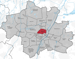
Maxvorstadt es un barrio del centro de Múnich (Alemania) que constituye el distrito 3 Maxvorstadt. Desde 1992, este barrio incluye los antiguos barrios 5, 6 y 7 (Maxvorstadt-Universität, Maxvorstadt-Königsplatz-Marsfeld y Maxvorstadt-Josephsplatz).
© MMXXIII Rich X Search. We shall prevail. All rights reserved. Rich X Search