Back آزاد كشمير Arabic Azad Kəşmir Azerbaijani آزاد کشمیر AZB Азат Кәшмир Bashkir Азад Кашмір Byelorussian Азад Кашмір BE-X-OLD Азад Кашмир Bulgarian आजाद काश्मीर Bihari আজাদ কাশ্মীর Bengali/Bangla Azad Kashmir Catalan
Azad Kashmir
آزاد جموں و کشمیر | |
|---|---|
Autonomous State | |
| Azād Jāmmu wa Kāshmir | |
 | |
|
| |
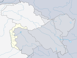
 Location of Azad Jammu and Kashmir | |
 | |
| Coordinates: 34°13′N 73°17′E / 34.22°N 73.28°E | |
| Country | Pakistan |
| Established | 24 October 1947 |
| Capital | Muzaffarabad |
| Largest city | Mirpur |
| Government | |
| • Type | Autonomous territory of Pakistan |
| • Body | Legislative Assembly |
| • President | [1] |
| • Prime Minister | [2] |
| Area | |
| • Total | 13,297 km2 (5,134 sq mi) |
| Population (2008; est.) | |
| • Total | 4,567,982 |
| • Density | 340/km2 (890/sq mi) |
| Time zone | UTC+5 (PKT) |
| ISO 3166 code | PK-JK |
| Main Language(s) |
|
| Assembly seats | 33[3] |
| Districts | 10 |
| Website | azadkashmir.gov.pk |
Azad Jammu and Kashmir, (Urdu: آزاد جموں و کشمیر پاکستان) also just called Azad Kashmir is a self-governing region that falls under Pakistan and is disputed region with India. In terms of land area it is bigger than Trinidad and Tobago but smaller than Brunei.
Geographically, to the north, is the Gilgit-Baltistan province, while to the south borders the province of Pakistani Punjabi, and to the east being the Indian-administered Kashmir.
The capital city of Azad Kashmir is Muzaffarabad. Azad Jammu and Kashmir has an area of 5,134 mi² (13,297 km²). The inhabitants of this region are Kashmiri citizens of ethnic Pahari origin. About 4 million people live there.
- ↑ "Pir Karam Ali Shah appointed GB Governor". The News. 26 January 2011. Archived from the original on 28 January 2011. Retrieved 28 January 2011.
- ↑ "Associated Press Of Pakistan ( Pakistan's Premier NEWS Agency ) - Public service policy to be pursued in Azad Kashmir: PM". Ftp.app.com.pk. Archived from the original on 16 August 2011. Retrieved 5 June 2010.
- ↑ Legislative Assembly will have directly elected 24 members, besides six women and three technocrats. "Azad Kashmir: New Pakistani Package or Governor Rule" 3 September 2009, The Unrepresented Nations and Peoples Organization (UNPO)
© MMXXIII Rich X Search. We shall prevail. All rights reserved. Rich X Search

