Back Kerseiland Afrikaans ክርስትማስ ደሴት Amharic Isla de Nadal AN Crīstesmæsse Īeg ANG क्रिस्मस द्वीप ANP جزيرة كريسماس Arabic جزيرة كريسماس ARZ Islla Christmas AST Milad adası Azerbaijani کریسمس آداسی AZB
Christmas Island | |
|---|---|
| Territory of Christmas Island 圣诞岛领地 / 聖誕島領地 (Chinese) Wilayah Pulau Krismas (Malay) | |
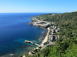
 Flying Fish Cove, the territory's capital | |
 Location of Christmas Island (red circle) and the location of Australia mainland (continent in red) | |
| Sovereign state | |
| British annexation | 6 June 1888 |
| Transferred from Singapore to Australia | 1 October 1958 |
| Named for | Christmas Day |
| Capital and largest city | Flying Fish Cove ("The Settlement") 10°25′18″S 105°40′41″E / 10.42167°S 105.67806°E |
| Official languages | None[a] |
| Spoken languages | |
| Ethnic groups |
|
| Demonym(s) | Christmas Islander |
| Government | Directly administered dependency |
• Monarch | Charles III |
| David Hurley | |
| Natasha Griggs | |
| Gordon Thompson | |
| Parliament of Australia | |
• Senate | represented by Northern Territory senators |
| included in the Division of Lingiari | |
| Area | |
• Total | 135 km2 (52 sq mi) |
• Water (%) | 0 |
| Highest elevation | 361 m (1,184 ft) |
| Population | |
• 2021 census | 1,692[1] (not ranked) |
• Density | 10.39/km2 (26.9/sq mi) (not ranked) |
| GDP (nominal) | 2010 estimate |
• Total | US$52,177,900[2] |
| Currency | Australian dollar (AU$) (AUD) |
| Time zone | UTC+07:00 (CXT) |
| Driving side | left |
| Calling code | +61 891 |
| Postcode | WA 6798 |
| ISO 3166 code | CX |
| Internet TLD | .cx[3] |
| Christmas Island | |||||||||||||||
| Simplified Chinese | 圣诞岛 | ||||||||||||||
|---|---|---|---|---|---|---|---|---|---|---|---|---|---|---|---|
| Traditional Chinese | 聖誕島 | ||||||||||||||
| |||||||||||||||
| Territory of Christmas Island | |||||||||||||||
| Simplified Chinese | 圣诞岛领地 | ||||||||||||||
| Traditional Chinese | 聖誕島領地 | ||||||||||||||
| |||||||||||||||


The Territory of Christmas Island is a small island that belongs to Australia. It is in the Indian Ocean, 2600 kms northwest of Perth in Western Australia and 500 km south of Jakarta, Indonesia.
About 1,600 people live on Christmas Island, mostly in a number of "settlement areas" on the north of the island:
- Flying Fish Cove
- Silver City
- Poon Saan
- Drumsite
Christmas Island is far from other islands. That is why many of the plants and animals are only found on that Island.[4] Much of it is undisturbed by humans.
There used to be mining on the island, but now 65% of Christmas Island is National Park.
Cite error: There are <ref group=lower-alpha> tags or {{efn}} templates on this page, but the references will not show without a {{reflist|group=lower-alpha}} template or {{notelist}} template (see the help page).
- ↑ "2021 Christmas Island, Census All persons QuickStats | Australian Bureau of Statistics". abs.gov.au. Retrieved 29 January 2023.
- ↑ Lundy, Kate (2010). "Chapter 3: The economic environment of the Indian Ocean Territories". Inquiry into the changing economic environment in the Indian Ocean Territories (PDF). Parliament House, Canberra: Joint Standing Committee on the National Capital and External Territories. p. 22. ISBN 978-0-642-79276-1.
- ↑ ".cx Domain Delegation Data". www.iana.org. Retrieved 4 February 2023.
- ↑ "Save Christmas Island - Introduction". The Wilderness Society. 19 September 2002. Retrieved 14 April 2007.
© MMXXIII Rich X Search. We shall prevail. All rights reserved. Rich X Search
