Back Hispaniola Afrikaans Hispaniola ALS Hispaniola AN Lytel Spēonland ANG هسبنيولا Arabic هيسبانيولا ARZ La Española AST Haiti adası Azerbaijani Гаити (утрау) Bashkir Гаіці (востраў) Byelorussian
| Hispaniola | |
|---|---|
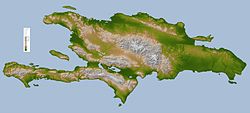
 Topographic map of Hispaniola | |
| Geography | |
| Location | Caribbean Sea |
| Archipelago | Antilles |
| Area | 76,480 km2 (29,529 sq mi) |
| Highest point | Pico Duarte (3,087 m) |
| Countries | |
| President | Jovenel Moise |
| Capital city | Port-au-Prince (703,023) |
| President | Luis Abinader |
| Capital city | Santo Domingo (790,191) |
| Demographics | |
| Population | 15,222,428 |
| Density | 263 |
Hispaniola is an island in the Caribbean Sea. It is the second largest island (after Cuba) of the West Indies, east of Cuba and west of Puerto Rico. It is the most populous island of the West Indies.
The Republic of Haiti occupies the western three-eighths,[1][2] the Dominican Republic the rest. Hispaniola is one of two Caribbean islands in which there are two countries; the other is Saint Martin.
- ↑ Dardik, Alan, ed. (2016). Vascular Surgery: A Global Perspective. Springer. p. 341. ISBN 9783319337456. Retrieved 8 May 2017.
- ↑ Josh, Jagran, ed. (2016). "Current Affairs November 2016 eBook". p. 93. Retrieved 8 May 2017.
© MMXXIII Rich X Search. We shall prevail. All rights reserved. Rich X Search