Back مقاطعة ليفينغستون (نيويورك) Arabic Livingston County, New York BAR Ливингстън (окръг, Ню Йорк) Bulgarian লিভিংটন কাউন্টি, নিউ ইয়র্ক BPY Livingston Gông (New York) CDO Ливингстон (гуо, Нью-Йорк) CE Livingston County (kondado sa Tinipong Bansa, New York) CEB Livingston County (New York) Czech Livingston County, Efrog Newydd Welsh Livingston County (New York) German
Livingston County | |
|---|---|
 | |
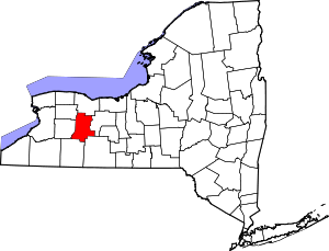
 Location within the U.S. state of New York | |
 New York's location within the U.S. | |
| Coordinates: 42°44′N 77°46′W / 42.73°N 77.77°W | |
| Country | |
| State | |
| Founded | 1821 |
| Named for | Robert R. Livingston |
| Seat | Geneseo |
| Largest village | Geneseo |
| Area | |
| • Total | 640 sq mi (1,700 km2) |
| • Land | 632 sq mi (1,640 km2) |
| • Water | 8.5 sq mi (22 km2) 1.3% |
| Population (2020) | |
| • Total | 61,834[1] |
| • Density | 97.9/sq mi (37.8/km2) |
| Time zone | UTC−5 (Eastern) |
| • Summer (DST) | UTC−4 (EDT) |
| Congressional district | 24th |
| Website | www |
Livingston County is a county in the U.S. state of New York. As of the 2020 census, the population was 61,834.[2] Its county seat is Geneseo.[3] The county is named after Robert R. Livingston, who helped draft the Declaration of Independence and negotiated the Louisiana Purchase. The county is part of the Finger Lakes region of the state.
Livingston County is part of the Rochester Metropolitan Statistical Area.
- ^ "US Census 2020 Population Dataset Tables for New York". United States Census Bureau. Retrieved January 2, 2022.
- ^ "U.S. Census Bureau QuickFacts: Livingston County, New York". United States Census Bureau. Retrieved January 2, 2022.
- ^ "Find a County". National Association of Counties. Archived from the original on May 31, 2011. Retrieved June 7, 2011.
© MMXXIII Rich X Search. We shall prevail. All rights reserved. Rich X Search

