Back Kula (Srbija) BS Кула (град) CE Kula (Srbsko) Czech Kula (Kula) German Kula Esperanto Kula (Voivodina) Spanish کولا (سربیا) Persian Kula (Voïvodine) French קולה (סרביה) HE Kula (Bačka) Croatian
Kula
| |
|---|---|
Town and municipality | |
Kula | |
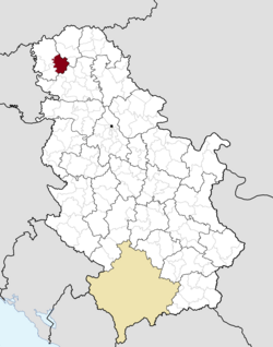
 Location of the municipality of Kula within Serbia | |
| Coordinates: 45°36′N 19°32′E / 45.600°N 19.533°E | |
| Country | |
| Province | |
| Region | Bačka |
| District | West Bačka |
| Municipality | Kula |
| Settlements | 7 |
| Government | |
| • Mayor | Damjan Miljanić (SNS) |
| Area | |
| • Municipality | 481 km2 (186 sq mi) |
| Elevation | 88 m (289 ft) |
| Population (2022 census)[2] | |
| • Town | 22,105 |
| • Municipality | 35,592 |
| Time zone | UTC+1 (CET) |
| • Summer (DST) | UTC+2 (CEST) |
| Postal code | 25230 |
| Area code | +381 25 |
| Car plates | SO |
| Website | www |

Kula (Serbian Cyrillic: Кула, Rusyn: Кула, Hungarian: Kúla) is a town and municipality located in the West Bačka District of the autonomous province of Vojvodina, Serbia. The town has a population of 22,105, while the municipality has a population of 35,592.[3]
- ^ "Municipalities of Serbia, 2006". Statistical Office of Serbia. Retrieved 2010-11-28.
- ^ "2022 Census of Population, Households and Dwellings: Ethnicity (data by municipalities and cities)" (PDF). Statistical Office of Republic Of Serbia, Belgrade. April 2023. ISBN 978-86-6161-228-2. Retrieved 2023-04-30.
- ^ "2022 Census of Population, Households and Dwellings" (PDF). Retrieved 2023-12-07.
© MMXXIII Rich X Search. We shall prevail. All rights reserved. Rich X Search


