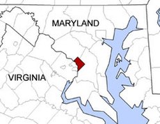
Washington, D.C. is located in the Mid-Atlantic region of the United States at 38°53′42″N 77°02′11″W / 38.89500°N 77.03639°W, the coordinates of the Zero Milestone, on The Ellipse. According to the United States Census Bureau, the city has a geographical area of 68.3 square miles (176.9 km2), 61.4 square miles (159.0 km2) of which is land, and the remaining 6.9 square miles (17.9 km2) (10.16%) of which is water. The Anacostia River and the smaller Rock Creek flow into the Potomac River in Washington.
Washington, D.C. is surrounded by Northern Virginia on its southwest side and Maryland on its southeast, northeast, and northwest sides; it interrupts those states' shared border, which is the south shore of the Potomac River both upstream and downstream from the city. The portion of the Potomac River that passes Washington, D.C. is virtually entirely within the city's border, as Washington, D.C. extends to the south bank. The city contains the remaining federal district, which was formerly part of those two adjacent states before they respectively ceded it for the national capital in the 1790s. The land ceded from Virginia was returned by Congress in 1847, so what remains of the modern District was all once part of Maryland.
© MMXXIII Rich X Search. We shall prevail. All rights reserved. Rich X Search
