Back Noord-Yorkshire Afrikaans Yorkshire d'o Norte AN شمال يوركشاير Arabic North Yorkshire AST Yorkshire Kalér BAN Паўночны Ёркшыр BE-X-OLD Северен Йоркшър Bulgarian উত্তর ইয়র্কশায়ার Bengali/Bangla Norzh Yorkshire Breton North Yorkshire Catalan
North Yorkshire | |
|---|---|
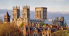
Top to bottom, left to right:
Ribblehead Viaduct in the Yorkshire Dales, the Tees Transporter Bridge in Middlesbrough, Staithes, and York Minster | |
 Location of North Yorkshire within England | |
| Coordinates: 54°10′N 1°20′W / 54.167°N 1.333°W | |
| Sovereign state | United Kingdom |
| Constituent country | England |
| Region | Yorkshire and the Humber and North East |
| Established | 1974 |
| Established by | Local Government Act 1972 |
| Origin | Yorkshire |
| Time zone | UTC+0 (GMT) |
| • Summer (DST) | UTC+1 (BST) |
| Members of Parliament | List of MPs |
| Police | North Yorkshire Police Cleveland Police |
| Largest town | Middlesbrough |
| Ceremonial county | |
| Lord Lieutenant | Johanna Ropner[1] |
| High Sheriff | Clare Deborah Granger (2023–24)[2] |
| Area | 8,654 km2 (3,341 sq mi) |
| • Ranked | 1st of 48 |
| Population (2022) | 1,158,816 |
| • Ranked | 14th of 48 |
| Density | 134/km2 (350/sq mi) |
| Ethnicity |
|
| Districts | |
 Districts of North Yorkshire | |
| Districts | Unitary: |
North Yorkshire is a ceremonial county in the Yorkshire and the Humber and North East regions of England.[note 1] It borders County Durham to the north, the North Sea to the east, the East Riding of Yorkshire to the south-east, South Yorkshire to the south, West Yorkshire to the south-west, and Cumbria and Lancashire to the west. Northallerton is the county town.
The county is the largest in England by land area, at 8,654 km2 (3,480 sq mi), and had a population of 1,158,816 in 2021. The largest settlements are Middlesbrough (148,215) in the north-east and the city of York (141,685) in the south. Middlesbrough is part of the Teesside built-up area, which extends into County Durham and has a total population of 376,663 in 2011. The remainder of the county is rural, and the largest towns are Harrogate (75,515) and Scarborough (59,505). For local government purposes the county comprises four unitary authority areas — Middlesbrough, North Yorkshire, Redcar and Cleveland, and York — and part of a fifth, Stockton-on-Tees. The local authorities of York and North Yorkshire are part of a combined authority of the same name, and the local authorities of the other three areas are part of the Tees Valley combined authority. The county was historically part of Yorkshire.
The centre of the county contains a wide plain, called the Vale of Mowbray in the north and Vale of York in the south. The North York Moors uplands lie to the east, and south of them the Vale of Pickering is separated from the main plain by the Howardian Hills. The west of the county contains the Yorkshire Dales, an extensive upland area which contains the source of the River Ouse/Ure and many of its tributaries, which together drain most of the county before reaching the Humber estuary in the south. The Dales also contain the county's highest point, Whernside, at 2,415 feet (736 m).[3]
- ^ "New Lord-Lieutenant of North Yorkshire appointed". Gazette & Herald. 13 November 2018. Retrieved 14 November 2018.
- ^ "No. 63990". The London Gazette. 10 March 2023. p. 4634.
- ^ "The County Tops". The Relative Hills of Britain. 26 July 2012. Archived from the original on 26 July 2012.
Cite error: There are <ref group=note> tags on this page, but the references will not show without a {{reflist|group=note}} template (see the help page).
© MMXXIII Rich X Search. We shall prevail. All rights reserved. Rich X Search


