Back Anhaltské vévodství Czech Hertugdømmet Anhalt Danish Herzogtum Anhalt German دوکنشین آنهالت Persian Anhaltin herttuakunta Finnish Duché d'Anhalt French דוכסות אנהלט HE Kadipaten Anhalt ID Ducato di Anhalt Italian アンハルト公国 Japanese
Duchy of Anhalt Herzogtum Anhalt | |||||||||||||
|---|---|---|---|---|---|---|---|---|---|---|---|---|---|
| 1863–1918 | |||||||||||||
 The Duchy of Anhalt within the German Empire | |||||||||||||
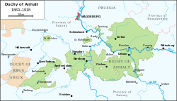
 Map of the Duchy of Anhalt (1863-1918) | |||||||||||||
| Status |
| ||||||||||||
| Capital | Dessau (when united) | ||||||||||||
| Common languages | German, Low German | ||||||||||||
| Religion | Evangelical Church of Anhalt | ||||||||||||
| Government | Duchy | ||||||||||||
| Duke | |||||||||||||
• 1863–1871 | Leopold IV (first) | ||||||||||||
• 1918 | Joachim Ernst (last) | ||||||||||||
| Historical era | Middle Ages | ||||||||||||
| 1806 | |||||||||||||
• German Revolution | 1918 | ||||||||||||
| Area | |||||||||||||
• Total | 3,800 km2 (1,500 sq mi) | ||||||||||||
| |||||||||||||
| Today part of | Germany | ||||||||||||
| |||||||||||||
The Duchy of Anhalt (German: Herzogtum Anhalt) was a historical German duchy. The duchy was located between the Harz Mountains in the west and the River Elbe and beyond to the Fläming Heath in the east. The territory was once ruled by the House of Ascania, and is now part of the federal state of Saxony-Anhalt.
© MMXXIII Rich X Search. We shall prevail. All rights reserved. Rich X Search

