Back Burgenland Afrikaans Burgenland ALS Burgenland AN بورغنلاند Arabic Burgenland AST Burgnland BAR Бургенланд Byelorussian Бургенлянд BE-X-OLD Бургенланд Bulgarian বুর্গেনলান্ড Bengali/Bangla
Burgenland | |
|---|---|
| Anthem: "Mein Heimatvolk, mein Heimatland" | |
 | |
| Country | |
| Capital | Eisenstadt |
| Government | |
| • Body | Landtag Burgenland |
| • Governor | Hans Peter Doskozil (SPÖ) |
| Area | |
| • Total | 3,680 km2 (1,420 sq mi) |
| Population (2023) | |
| • Total | 301,250 |
| • Density | 82/km2 (210/sq mi) |
| GDP | |
| • Total | €9.498 billion (2021) |
| • Per capita | €32,000 (2021) |
| Time zone | UTC+1 (CET) |
| • Summer (DST) | UTC+2 (CEST) |
| ISO 3166 code | AT-1 |
| HDI (2019) | 0.885[2] very high · 9th of 9 |
| NUTS Region | AT1 |
| Votes in Bundesrat | 3 (of 62) |
| Website | www |
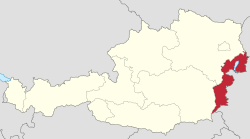
Burgenland (German pronunciation: [ˈbʊʁɡn̩lant] ⓘ; Hungarian: Őrvidék; Croatian: Gradišće; Austro-Bavarian: Burgnland; Slovene: Gradiščanska; Slovak: Hradsko) is the easternmost and least populous state of Austria. It consists of two statutory cities and seven rural districts, with a total of 171 municipalities. It is 166 km (103 mi) long from north to south but much narrower from west to east (5 km (3.1 mi) wide at Sieggraben). The region is part of the Centrope Project. The name of Burgenland was invented/coined in 1922, after its territories became part of Austria.[3]
- ^ "Basisdaten Bundesländer" (PDF). Archived (PDF) from the original on 2006-10-09. Retrieved 2023-09-01.
- ^ "Sub-national HDI – Area Database – Global Data Lab". hdi.globaldatalab.org. Retrieved 2018-09-13.
- ^ "Archived copy" (PDF). Archived from the original on April 10, 2023. Retrieved July 30, 2023.
{{cite web}}: CS1 maint: archived copy as title (link) CS1 maint: bot: original URL status unknown (link)
© MMXXIII Rich X Search. We shall prevail. All rights reserved. Rich X Search

