Back جغرافيا رومانيا Arabic Геаграфія Румыніі Byelorussian География на Румъния Bulgarian রোমানিয়ার ভূগোল Bengali/Bangla Geographie Rumäniens German Geografía de Rumania Spanish جغرافیای رومانی Persian Romanian maantiede Finnish Géographie de la Roumanie French Xeografía de Romanía Galician
This article includes a list of general references, but it lacks sufficient corresponding inline citations. (August 2014) |
 | |
| Continent | Europe |
|---|---|
| Region | Balkan Peninsula and Eastern Europe |
| Coordinates | 46°00′N 25°00′E / 46.000°N 25.000°E |
| Area | Ranked 81st |
| • Total | 238,397 km2 (92,046 sq mi) |
| • Land | 97.03% |
| • Water | 2.97% |
| Coastline | 245 km (152 mi) |
| Borders | 3,149.9 |
| Highest point | Moldoveanu Peak 2,544 metres (8,346 ft), Negoiu Peak 2,535 metres (8,317 ft) |
| Lowest point | Black Sea 0 metres (0 ft) |
| Longest river | Olt River 615 kilometres (382 mi) |
| Largest lake | Lake Razelm 511 km2 (197.30 sq mi) |
| Exclusive economic zone | 23,627 km2 (9,122 sq mi) |
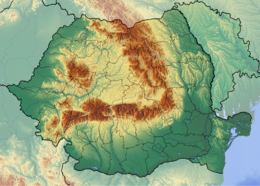
With an area of 238,397 km2 (92,046 sq mi), Romania is the twelfth-largest country in Europe. It is a Balkan country located at the crossroads of Eastern and Southeast Europe. It's bordered on the Black Sea, the country is halfway between the equator and the North Pole and equidistant from the westernmost part of Europe—the Atlantic Coast—and the most easterly—the Ural Mountains. Romania has 3,195 kilometres (1,985 mi) of border. Republic of Moldova and Ukraine lies to the east, Bulgaria lies to the south, and Serbia and Hungary to the west by the Pannonian Plain. In the southeast, 245 kilometres (152 mi) of sea coastline provide an important outlet to the Black Sea and the Atlantic Ocean.
© MMXXIII Rich X Search. We shall prevail. All rights reserved. Rich X Search