Back جبل الزيتون Arabic جبل الزيتون ARZ Zeytun dağı Azerbaijani Елеонски хълм Bulgarian জয়তুন পর্বত Bengali/Bangla Mont de les Oliveres Catalan Mount of Olives (tagaytay) CEB Olivová hora Czech Oliebjerget Danish Ölberg (Jerusalem) German
| Mount of Olives | |
|---|---|
| Mount Olivet | |
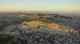
 Aerial photograph of the Mount of Olives | |
| Highest point | |
| Elevation | 826 m (2,710 ft) |
| Coordinates | 31°46′42″N 35°14′38″E / 31.77833°N 35.24389°E |
| Naming | |
| Native name | |
| Geography | |
| Location | Jerusalem |
| Parent range | Judean Mountains |
| Climbing | |
| Easiest route | Road |

The Mount of Olives or Mount Olivet (Hebrew: הַר הַזֵּיתִים, romanized: Har ha-Zeitim; Arabic: جبل الزيتون, romanized: Jabal az-Zaytūn; both lit. 'Mount of Olives'; in Arabic also الطور, Aṭ-Ṭūr, 'the Mountain') is a mountain ridge in East Jerusalem, east of and adjacent to Jerusalem's Old City.[1] It is named for the olive groves that once covered its slopes. The southern part of the mount was the Silwan necropolis, attributed to the elite of the ancient Kingdom of Judah.[2] The western slopes of the mount, those facing Jerusalem, have been used as a Jewish cemetery for over 3,000 years and holds approximately 150,000 graves, making it central in the tradition of Jewish cemeteries.[3] Atop the hill lies the Palestinian neighbourhood of At-Tur, a former village that is now part of East Jerusalem.
Several key events in the life of Jesus, as related in the Gospels, took place on the Mount of Olives, and in the Acts of the Apostles it is described as the place from which Jesus ascended to heaven. Because of its association with both Jesus and Mary, the mount has been a site of Christian worship since ancient times and is today a major site of pilgrimage for Catholics, the Eastern Orthodox, and Protestants.
- ^ Har-El, Menashe (1977). This is Jerusalem. Jerusalem: Canaan Publishing House. p. 117.
- ^ Cite error: The named reference
Ussishkin70was invoked but never defined (see the help page). - ^ "International committee vows to restore Mount of Olives". Ynetnews. 8 November 2010.
© MMXXIII Rich X Search. We shall prevail. All rights reserved. Rich X Search