| Shornemead Fort | |
|---|---|
| close to Higham, Kent | |
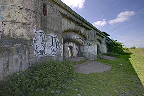
 View of the exterior of the casemates of Shornemead Fort | |
| Coordinates | 51°26′48″N 0°26′03″E / 51.446768°N 0.434059°E |
| Type | Fortification |
| Site information | |
| Controlled by | Royal Society for the Protection of Birds |
| Open to the public | Yes |
| Condition | Mostly demolished |
| Site history | |
| Built | ca. 1861–70 |
| Built by | United Kingdom |
| In use | 1870–1950s |
| Materials | Concrete, granite |
| Demolished | 1960s |
| Battles/wars | First World War, Second World War |
Shornemead Fort is a now-disused artillery fort that was built in the 1860s to guard the entrance to the Thames from seaborne attack. Constructed during a period of tension with France, it stands on the south bank of the river at a point where the Thames curves sharply north and west, giving the fort long views up and downriver in both directions. It was the third fort constructed on the site since the 18th century, but its location on marshy ground led to major problems with subsidence. The fort was equipped for a time with a variety of large-calibre artillery guns which were intended to support two other nearby Thamesside forts. However, the extent of the subsidence meant that it became unsafe for the guns to be fired and the fort was disarmed by the early 20th century.
Shornemead Fort was in use from its completion in 1870 to its abandonment in the 1950s. Much of it was demolished by the Army Demolition School of the Royal Engineers in the 1960s. The barracks and administrative buildings have been completely destroyed and only the front of the casemates survives along with the magazines underneath, though the latter are now flooded and inaccessible. The surviving fragments of the fort and the area around it are part of a nature reserve and can be visited by the public.
© MMXXIII Rich X Search. We shall prevail. All rights reserved. Rich X Search

