Back Doornik Afrikaans طرناي Arabic تورناى ARZ Турнэ Byelorussian Турнэ BE-X-OLD Турне Bulgarian Tournai Breton Tournai Catalan Tournai (parokya) CEB Tournai Czech
This article needs additional citations for verification. (March 2015) |
Tournai
Tornai (Picard) | |
|---|---|
City and municipality | |
 | |
| Coordinates: 50°36′20″N 03°23′17″E / 50.60556°N 3.38806°E | |
| Country | |
| Community | French Community |
| Region | Wallonia |
| Province | Hainaut |
| Arrondissement | Tournai |
| Government | |
| • Mayor | Paul-Olivier Delannois (PS) |
| • Governing party/ies | PS-cdH |
| Area | |
| • Total | 215.34 km2 (83.14 sq mi) |
| Population (2018-01-01)[1] | |
| • Total | 69,554 |
| • Density | 320/km2 (840/sq mi) |
| Postal codes | 7500-7548 |
| NIS code | 57081 |
| Area codes | 069 |
| Website | tournai.be |
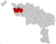
Tournai or Tournay (/tʊərˈneɪ/ toor-NAY; French: [tuʁnɛ] ⓘ; Dutch: Doornik [ˈdoːrnɪk] ⓘ; Picard: Tornai; Walloon: Tornè [tɔʀnɛ] ⓘ; Latin: Tornacum) is a city and municipality of Wallonia located in the Province of Hainaut, Belgium. It lies 89 km (55 mi) by road southwest of the centre of Brussels on the river Scheldt,[2] and is part of Eurometropolis Lille–Kortrijk–Tournai,[3] In 2022, the municipality of Tournai had an estimated population of 68,518 people.[4]
Tournai is one of the oldest cities in Belgium and has played an important role in the country's cultural history. It was the first capital of the Frankish Empire, with Clovis I being born here.
- ^ "Wettelijke Bevolking per gemeente op 1 januari 2018". Statbel. Retrieved 9 March 2019.
- ^ Google (15 March 2023). "Tournai" (Map). Google Maps. Google. Retrieved 15 March 2023.
- ^ "EUROMETROPOLIS: Eurometropolis Lille-Kortrijk-Tournai, the 1st european cross-bordrer metropolis". eurometropolis.eu. Retrieved 15 March 2023.
- ^ "Tournai". Citypopulation.de. Retrieved 15 March 2023.
© MMXXIII Rich X Search. We shall prevail. All rights reserved. Rich X Search


