Back Wuhanbroen Danish Jangtse-Brücke (Wuhan) German Puente de Wuhan sobre el río Yangtsé Spanish Wuhan Yangtze ibaiko zubia Basque Pont de Wuhan French Jembatan Sungai Yangtze Wuhan ID Ponte di Wuhan Italian 武漢長江大橋 Japanese 우한장강대교 Korean Wuhan-Yangtzebrug Dutch
Wuhan Yangtze River Bridge 武汉长江大桥 | |
|---|---|
 | |
| Coordinates | 30°32′59″N 114°17′18″E / 30.5497°N 114.2882°E |
| Carries | 4 lanes Highway 2 tracks of the Beijing–Guangzhou Railway |
| Crosses | Yangtze River |
| Locale | Wuhan, Hubei, China |
| Other name(s) | Wuhan Great Bridge |
| Characteristics | |
| Design | Truss bridge |
| Total length | 1,670 metres (5,480 ft) |
| Width | 22.5 metres (74 ft) |
| Longest span | 128 metres (420 ft) |
| History | |
| Constructed by | Wuhan Great Bridge Engineering Bureau |
| Construction start | 1 September 1955 |
| Construction end | September 1957 |
| Opened | 15 October 1957 |
| Location | |
 | |

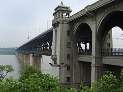
The Wuhan Yangtze Great Bridge (simplified Chinese: 武汉长江大桥; traditional Chinese: 武漢長江大橋; pinyin: Wǔhàn Chángjiāng Dàqiáo), commonly known as Wuhan First Yangtze Bridge, is a double-deck road and rail bridge across the Yangtze River in Wuhan, in Central China. At its completion in 1957, the bridge was the easternmost crossing of the Yangtze, and was often referred to as the "First Bridge of the Yangtze".
The bridge extends 1.6 kilometers (1 mile) from Turtle Hill in Hanyang, on the northern bank of the Yangtze, to Snake Hill in Wuchang, on the southern bank of the Yangtze. Plans for the bridge's construction were first made in 1910. A total of four exploratory surveys were made between 1913 and 1948 to identify a suitable site, but economic limitations and the combination of World War II and the Chinese Civil War prevented the bridge's building until the 1950s. Actual construction began in September 1955 and was completed in October 1957.
The upper level of the bridge is a two-way, four-lane automobile highway. The lower level is a double-track railway on the Beijing-Guangzhou railway line.
© MMXXIII Rich X Search. We shall prevail. All rights reserved. Rich X Search