| Concord Naval Weapons Station | |
|---|---|
| Concord, California | |
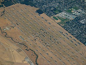
 Aerial view taken in 2006 | |
| Type | Military base |
| Site information | |
| Controlled by | United States Army |
| Condition | Operational |
| Website | https://concordreuseproject.org/ |
| Site history | |
| Built | 1942 |
| In use | 1942 – present |
| Events | Port Chicago disaster |
| Garrison information | |
| Garrison | 834th Transportation Battalion |
37°59′39″N 121°58′58″W / 37.99417°N 121.98278°W[1]
Concord Naval Weapons Station was a military base established in 1942 north of the city of Concord, California at the shore of the Sacramento River where it widens into Suisun Bay. The station functioned as a World War II armament storage depot, supplying ships at Port Chicago. During World War II it also had a Naval Outlying Field at the southern edge of the base. It ceased being an operating airfield after World War II. During the Korean War, the Vietnam War and the Gulf War, Concord NWS processed and shipped thousands of tons of materiel out across the Pacific Ocean.[2]
The station consisted of two areas: the Inland Area (5,028 acres (2,035 ha)), which is within the Concord city limits, and the Tidal Area (7,630 acres (3,088 ha)).[3] Because of changes in military operations, parts of the Inland Area began to be mothballed, and by 1999 the station had only a minimal contingent of military personnel and contained mainly empty ammunition storage bunkers, empty warehouses, and disused support structures. In 2007, the U.S. federal government announced that the Inland Area of the Naval station would be closed. The Tidal area of the base was not scheduled for closure and reorganized as Military Ocean Terminal Concord (MOTCO).[2] The 834th Transportation Battalion is the port manager at MOTCO and operates the three piers and an Army-owned rail system that connects with major public railway lines.[4]
The 5-member City Council of Concord, sitting as the federally designated Local Reuse Authority, is in the process of formulating a Reuse Plan for the Inland Area that includes residential and commercial development while reserving approximately two-thirds for open-space and parks projects.[5] City staff are assigned to manage this effort. The Reuse Plan is subject to approval by the Navy.[3][6]
The East Bay Regional Park District will be receiving 2,540 acres (1028 hectares) of the Inland Area that will be developed for public use as Concord Hills Regional Park. Formal conveyance of the property was expected in early 2016 whereupon the property will be prepared for public access and recreation.[7][needs update] Since then 2,216 acres were transferred from Navy property to park.[8] In addition "2,300 acres will be transferred to the city of Concord, whose Concord Community Reuse Project has been overseeing planning for housing, businesses, a college campus and other development.".[8]
- ^ United States Geological Survey (17 November 2008). "GNIS Detail – Naval Weapons Station Concord". Geographic Names Information System. United States Geological Survey. Retrieved 2010-01-01.
- ^ a b Concord Naval Weapons Station Reuse Information Portal Archived 2013-09-21 at the Wayback Machine. Retrieved 2007-08-13
- ^ a b About the City of Concord Community Reuse Project Archived 2007-10-09 at the Wayback Machine, official city web site'. Retrieved 2007-08-13
- ^ SDDC Military Ocean Terminal Concord (MOTCO)
- ^ "Concord Reuse Project". Official Reuse Project website. Retrieved 2010-01-26
- ^ "Concord Naval Weapons Station". Contra Costa Times website collection of articles. Retrieved 2007-08-13
- ^ Concord Hills Regional Park Archived 2015-04-18 at the Wayback Machine, East Bay Regional Park District website notice. Retrieved 2015-04-23
- ^ a b "Land Use Plan Approved For Park On Concord Naval Weapons Station Site". 2020-07-13. Retrieved 2021-03-15.
© MMXXIII Rich X Search. We shall prevail. All rights reserved. Rich X Search
