San Carlos | ||||||||||||||||||||||||||||||||||
|---|---|---|---|---|---|---|---|---|---|---|---|---|---|---|---|---|---|---|---|---|---|---|---|---|---|---|---|---|---|---|---|---|---|---|
 A northbound train at San Carlos station in 2018 | ||||||||||||||||||||||||||||||||||
| General information | ||||||||||||||||||||||||||||||||||
| Location | 599 El Camino Real San Carlos, California | |||||||||||||||||||||||||||||||||
| Coordinates | 37°30′29″N 122°15′37″W / 37.50806°N 122.26028°W | |||||||||||||||||||||||||||||||||
| Owned by | Peninsula Corridor Joint Powers Board | |||||||||||||||||||||||||||||||||
| Line(s) | Peninsula Subdivision[1] | |||||||||||||||||||||||||||||||||
| Platforms | 2 side platform | |||||||||||||||||||||||||||||||||
| Tracks | 2 | |||||||||||||||||||||||||||||||||
| Connections | ||||||||||||||||||||||||||||||||||
| Construction | ||||||||||||||||||||||||||||||||||
| Structure type | Elevated | |||||||||||||||||||||||||||||||||
| Parking | Available | |||||||||||||||||||||||||||||||||
| Bicycle facilities | 24 racks, lockers | |||||||||||||||||||||||||||||||||
| Accessible | Yes | |||||||||||||||||||||||||||||||||
| Other information | ||||||||||||||||||||||||||||||||||
| Fare zone | 2 | |||||||||||||||||||||||||||||||||
| History | ||||||||||||||||||||||||||||||||||
| Opened | 1888 | |||||||||||||||||||||||||||||||||
| Rebuilt | 1997 | |||||||||||||||||||||||||||||||||
| Original company | Southern Pacific | |||||||||||||||||||||||||||||||||
| Passengers | ||||||||||||||||||||||||||||||||||
| 2018 | 1,331 per weekday[2] | |||||||||||||||||||||||||||||||||
| Services | ||||||||||||||||||||||||||||||||||
| ||||||||||||||||||||||||||||||||||
| ||||||||||||||||||||||||||||||||||
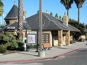
Southern Pacific Depot | ||||||||||||||||||||||||||||||||||
 San Carlos station building in 2011 | ||||||||||||||||||||||||||||||||||
| Area | 2.753 acres (1.114 ha) | |||||||||||||||||||||||||||||||||
| Architectural style | Richardsonian Romanesque | |||||||||||||||||||||||||||||||||
| NRHP reference No. | 84001191 [3] | |||||||||||||||||||||||||||||||||
| Added to NRHP | September 20, 1984 | |||||||||||||||||||||||||||||||||
| ||||||||||||||||||||||||||||||||||
San Carlos is a Caltrain commuter rail station in San Carlos, California.
- ^ SMA Rail Consulting (April 2016). "California Passenger Rail Network Schematics" (PDF). California Department of Transportation. p. 13.
- ^ "2018 Annual Count Key Findings Report" (PDF). Caltrain. 2018. Archived from the original (PDF) on 2020-05-20. Retrieved 2018-10-17.
- ^ "National Register Information System". National Register of Historic Places. National Park Service. April 15, 2008.
© MMXXIII Rich X Search. We shall prevail. All rights reserved. Rich X Search

