Back Katastrální mapa Czech Katastermappe German Plat English Plano (cartografía) Spanish Plano (kartografia) Basque Plano Galician Földmérési alaptérkép Hungarian საკადასტრო რუკა Georgian Mapa ewidencyjna Polish Кадастрова карта Ukrainian

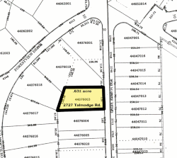
In the United States, a plat (/plæt/[1] or /plɑːt/)[2] (plan) is a map that shows the parts of a piece of land for where houses and buildings will be built.
After filing a plat, legal descriptions can start using block and lot-numbers instead of calling them portions of sections.[3]
- ↑ American Heritage Dictionary, 3rd ed., s.v. "plat."
- ↑ from a letter published in The Gentleman's Magazine, Volume 72, Part 1, London, 1802 [1]: "... many attorneys ought to be whipt for not knowing how to spell; that plot a conspiracy and plat a piece of ground were pronounced exactly alike ..."
- ↑ "City of Corpus". Cctexas.com. Retrieved 2012-12-13.
© MMXXIII Rich X Search. We shall prevail. All rights reserved. Rich X Search