Back Wannsee Afrikaans وانسي Arabic Wannsee CEB Wannsee Danish Berlin-Wannsee German وانزی Persian Berlin-Wannsee French ואנזה (פרבר) HE Wannsee (városrész) Hungarian Wannsee Italian
Wannsee | |
|---|---|
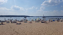
 The beach of Wannsee (Strandbad Wannsee) | |
| Coordinates: 52°25′00″N 13°09′00″E / 52.41667°N 13.15000°E | |
| Country | Germany |
| State | Berlin |
| City | Berlin |
| Borough | Steglitz-Zehlendorf |
| Founded | 1870 |
| Subdivisions | 5 zones |
| Area | |
• Total | 23.7 km2 (9.2 sq mi) |
| Elevation | 103 m (338 ft) |
| Population (2023-12-31)[1] | |
• Total | 10,237 |
| • Density | 430/km2 (1,100/sq mi) |
| Time zone | UTC+01:00 (CET) |
| • Summer (DST) | UTC+02:00 (CEST) |
| Postal codes | 14109 |
| Vehicle registration | B |
Wannsee (German pronunciation: [ˈvanˌzeː] ⓘ) is a locality in the southwestern Berlin borough of Steglitz-Zehlendorf, Germany. It is the westernmost locality of Berlin. In the quarter there are two lakes, the larger Großer Wannsee (Greater Wannsee) and the Kleiner Wannsee (Little Wannsee), located on the Havel and separated by the Wannsee Bridge. The larger of the two lakes covers an area of 2.7 km2 (1.0 sq mi) and has a maximum depth of 9 m (30 ft).
The municipality is the location of the compound where the mass extermination of Europe's Jewish population, known as the "Final Solution", was planned and approved at the Wannsee Conference in early 1942 by the Nazi Party's highest-ranking officials, including Reinhard Heydrich and Adolf Eichmann.[2]
- ^ "Einwohnerinnen und Einwohner im Land Berlin am 31. Dezember 2023". Amt für Statistik Berlin-Brandenburg. February 2024.
- ^ Pearson, Jim; Glass, Adam. "Wannsee Conference and The Final Solution". Holocaust Encyclopedia. United States Holocaust Museum. Retrieved 1 November 2024.
© MMXXIII Rich X Search. We shall prevail. All rights reserved. Rich X Search


