Back Angers ACE Angers Afrikaans Angers ALS አንዤ Amharic Angers AN أنجيه Arabic انجيه ARZ Angers AST Angers AVK Anje Azerbaijani
 | |
| Melumat | |
| Dewlete | Fransa |
| Mıntıqa | Communauté urbaine Angers Loire Métropole |
| Merkezê idarey | Maine-et-Loire, Anjou, arrondissement of Angers, canton of Angers-Sud, canton of Angers-Est, canton of Angers-Nord, canton of Angers-Ouest, canton of Angers-Trélazé, canton of Angers-Nord-Est, canton of Angers-Centre, canton of Angers-Nord-Ouest, canton of Angers-3, canton of Angers-2, canton of Angers-1, canton of Angers-4, canton of Angers-5, canton of Angers-6 û canton of Angers-7 |
| Ware | Maine-et-Loire, Communauté urbaine Angers Loire Métropole û arrondissement of Angers |
| Erd | 42,71 km2 |
| Nıfus | 157 175 |
| Berziye | 20 m |
| Serdar | Q118314528 |
| Letey saete | UTC+01.00 |
| Kodê postey | 49000 |
| Geokod | 3037656 |
| Website | www.angers.fr |
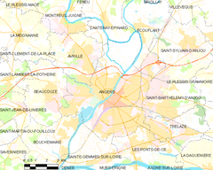
| Xerita | |
 | |
| Wikidata sera bıvurne | |
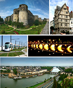
Angers, jû sûka dewleta Fransaya.[1] Erdê sûke 42,7 km2 ca gêno. Na sûke 20 m derya ra berza.
© MMXXIII Rich X Search. We shall prevail. All rights reserved. Rich X Search

