Back زلزال أكادير 1960 Arabic زلزال أݣادير 1960 ARY 1960 Aqadir zəlzələsi Azerbaijani Земетресение в Агадир (1960) Bulgarian Terratrèmol d'Agadir de 1960 Catalan Агадирехь мохкбегор (1960) CE Zemětřesení v Agádíru 1960 Czech Jordskælvet i Agadir 1960 Danish Erdbeben von Agadir 1960 German Σεισμός στο Αγκαντίρ (1960) Greek
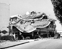
 Building damage in Agadir | |
| UTC time | 1960-02-29 23:40:18 |
|---|---|
| ISC event | 878424 |
| USGS-ANSS | ComCat |
| Local date | 29 February 1960 |
| Local time | 23:40:18 WET (UTC±00:00) |
| Duration | < 15 seconds[1] |
| Magnitude | 5.8 Mw[2] |
| Depth | 15 km[3] |
| Epicenter | 30°21′N 9°41′W / 30.35°N 9.69°W[3] |
| Areas affected | Morocco |
| Max. intensity | MMI X (Extreme)[4] |
| Foreshocks | 23 February MMI III (Weak)[5] 29 February MMI VI (Strong)[5] |
| Aftershocks | 22 March MMI VI (Strong) 17 April MMI VI (Strong)[5] |
| Casualties | ~ 12,000–15,000 dead[4] ~ 12,000 injured[6] |
The 1960 Agadir earthquake occurred on 29 February at 23:40:18 Western European Time near the city of Agadir, located in western Morocco on the shore of the Atlantic Ocean. Despite the earthquake's moderate Mw scale magnitude of 5.8, its relatively shallow depth (15.0 km[7]) resulted in strong surface shaking, with a maximum perceived intensity of X (Extreme) on the Mercalli intensity scale. Between 12,000 and 15,000 people (about a third of the city's population of the time) were killed and another 12,000 injured with at least 35,000 people left homeless, making it the most destructive and deadliest earthquake in Moroccan history. Particularly hard hit were Founty, the Kasbah, Yachech/Ihchach and the Talborjt area. The earthquake's shallow focus, close proximity to the port city of Agadir, and unsatisfactory construction methods were all reasons declared by earthquake engineers and seismologists as to why it was so destructive.
© MMXXIII Rich X Search. We shall prevail. All rights reserved. Rich X Search
