Back موسم أعاصير شمال المحيط الهندي (2019) Arabic ২০১৯ উত্তর ভারত মহাসাগর ঘূর্ণিঝড় মৌসুম Bengali/Bangla Temporada de ciclones en el Índico Norte de 2019 Spanish 2019년 북인도양 사이클론 Korean Temporada de ciclones no Índico Norte de 2019 Portuguese 2019 North Indian Ocean cyclone season SIMPLE ฤดูพายุไซโคลนมหาสมุทรอินเดียเหนือ พ.ศ. 2562 Thai Mùa bão Bắc Ấn Độ Dương 2019 Vietnamese 2019年北印度洋氣旋季 Chinese
| 2019 North Indian Ocean cyclone season | |
|---|---|
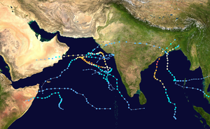
 Season summary map | |
| Seasonal boundaries | |
| First system formed | January 4, 2019 |
| Last system dissipated | December 10, 2019 |
| Strongest storm | |
| Name | Kyarr |
| • Maximum winds | 240 km/h (150 mph) (3-minute sustained) |
| • Lowest pressure | 922 hPa (mbar) |
| Seasonal statistics | |
| Depressions | 12 |
| Deep depressions | 11 |
| Cyclonic storms | 8 |
| Severe cyclonic storms | 6 (record high) |
| Very severe cyclonic storms | 6 (record high) |
| Extremely severe cyclonic storms | 3 (record high, tied with 1999 and 2023) |
| Super cyclonic storms | 1 |
| Total fatalities | 185 total |
| Total damage | > $11.63 billion (2019 USD) (Third-costliest North Indian Ocean cyclone season on record) |
| Related articles | |
The 2019 North Indian Ocean cyclone season was the second most active North Indian Ocean cyclone season on record in terms of cyclonic storms, the 1992 season was more active according to the Joint Typhoon Warning Center. The season featured 12 depressions, 11 deep depressions, 8 cyclonic storms, 6 severe cyclonic storms, 6 very severe cyclonic storms, 3 extremely severe cyclonic storms, and 1 super cyclonic storm, Kyarr, the first since Cyclone Gonu in 2007. Additionally, it also became the third-costliest season recorded in the North Indian Ocean, only behind the 2020 and 2008 seasons.
The season's first named storm, Pabuk, entered the basin on January 4, becoming the earliest-forming cyclonic storm of the North Indian Ocean on record. The second cyclone of the season, Cyclone Fani, at the time was the strongest tropical cyclone in the Bay of Bengal by 3-minute maximum sustained wind speed until it got tied with Cyclone Mocha of 2023, and minimum barometric pressure since the 1999 Odisha cyclone, while being equal in terms of maximum 3-minute sustained wind speed to 2007's Sidr and 2013's Phailin. Further activity occurred in October, and in the latter part of that month, the first and only super cyclonic storm of the 2010s, Kyarr, formed.
The scope of this article is limited to the Indian Ocean in the Northern Hemisphere, east of the Horn of Africa and west of the Malay Peninsula. There are two main seas in the North Indian Ocean — the Arabian Sea to the west of the Indian subcontinent, abbreviated ARB by the India Meteorological Department (IMD); and the Bay of Bengal to the east, abbreviated BOB by the IMD.
The official Regional Specialized Meteorological Centre in this basin is the India Meteorological Department (IMD), while the Joint Typhoon Warning Center (JTWC) and the National Meteorological Center of CMA (NMC) unofficially release full advisories. On average, three to four cyclonic storms form in this basin every season.[1][2]
- ^ "Annual Frequency of Cyclonic Disturbances (Maximum Wind Speed of 17 Knots or More), Cyclones (34 Knots or More) and Severe Cyclones (48 Knots or More) Over the Bay of Bengal (BOB), Arabian Sea (AS) and Land Surface of India" (PDF). India Meteorological Department. Retrieved 30 October 2015.
- ^ RSMC — Tropical Cyclones New Delhi (2010). Report on Cyclonic Disturbances over North Indian Ocean during 2009 (PDF) (Report). India Meteorological Department. pp. 2–3. Archived from the original (PDF) on 2010-12-04. Retrieved May 24, 2011.
© MMXXIII Rich X Search. We shall prevail. All rights reserved. Rich X Search