| Abingdon Lock | |
|---|---|
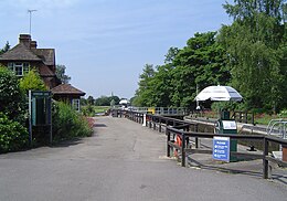
 Abingdon Lock with Abingdon downstream in the distance. The silver parasols are to shade the lock-keeper while operating the controls. Yellow boards on the gates indicate a high stream | |
 | |
| 51°40′14″N 1°16′09″W / 51.670535°N 1.269202°W | |
| Waterway | River Thames |
| County | Oxfordshire |
| Maintained by | Environment Agency |
| Operation | Hydraulic |
| First built | 1790 |
| Latest built | 1905 |
| Length | 36.57 m (120 ft 0 in) [1] |
| Width | 5.71 m (18 ft 9 in)[1] |
| Fall | 1.89 m (6 ft 2 in)[1] |
| Above sea level | 167' |
| Distance to Teddington Lock | 85 miles |
Abingdon Lock | |||||||||||||||||||||||||||||||||||||||||||||||||||||||||||||||||||||||||||||||||||||||||||||||||||||||||||||||||||||||
|---|---|---|---|---|---|---|---|---|---|---|---|---|---|---|---|---|---|---|---|---|---|---|---|---|---|---|---|---|---|---|---|---|---|---|---|---|---|---|---|---|---|---|---|---|---|---|---|---|---|---|---|---|---|---|---|---|---|---|---|---|---|---|---|---|---|---|---|---|---|---|---|---|---|---|---|---|---|---|---|---|---|---|---|---|---|---|---|---|---|---|---|---|---|---|---|---|---|---|---|---|---|---|---|---|---|---|---|---|---|---|---|---|---|---|---|---|---|---|---|
| |||||||||||||||||||||||||||||||||||||||||||||||||||||||||||||||||||||||||||||||||||||||||||||||||||||||||||||||||||||||

Abingdon Lock is a lock on the River Thames in England, less than 1 mile east and upstream of Abingdon, Oxfordshire, on the opposite bank of the river. It was originally built in 1790 by the Thames Navigation Commission.
The weir runs across from the Abingdon side to the lock island, and has a pedestrian walkway across it.
According to a tablet above the front door, the current lock-keeper's house dates from 1928. Ice creams and refreshments have been sold from the door of the house for at least 30 years.
- ^ a b c "Environment Agency Dimensions of locks on the River Thames". web page. Environmental Agency. 8 November 2012. Retrieved 17 November 2012. Dimensions given in metres
© MMXXIII Rich X Search. We shall prevail. All rights reserved. Rich X Search
