Back الأشرفية (بيروت) Arabic الاشرفيه ARZ Achrafieh AST আশরাফিহ Bengali/Bangla ئەشڕەفیە CKB Aschrafiyya German Achrafieh Spanish اشرفیه Persian Achrafieh French אשרפייה HE
Achrafieh
الأشرفية | |
|---|---|
District | |
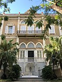
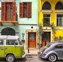
From left to right: Sursock Palace, Zahrat al-Ihsan Street, and a colourful street in Achrafieh | |
 Location of Achrafieh within Beirut | |
| Coordinates: 33°53′15.21″N 35°31′14.72″E / 33.8875583°N 35.5207556°E | |
| Country | |
Achrafieh (Arabic: الأشرفية) is an upper-class area in eastern Beirut, Lebanon.[1] In strictly administrative terms, the name refers to a sector (secteur) centred on Sassine Square, the highest point in the city, as well as a broader quarter (quartier). In popular parlance, however, Achrafieh refers to the whole hill that rises above Gemmayze in the north and extends to Badaro in the south, and includes the Rmeil quarter.
Although there are traces of human activity dating back to the neolithic era, the modern suburb was heavily settled by Greek Orthodox merchant families from Beirut's old city in the mid-nineteenth century.[2] The area contains a high concentration of Beirut's Ottoman and French Mandate era architectural heritage. During the civil war, when Beirut was separated into eastern and western halves by the Green Line, Achrafieh changed from a mostly Christian residential area (compared to bustling, cosmopolitan Hamra, in Ras Beirut) to a commercial hub in its own right. In the early 2000s, the area became a focal point of the city's real estate boom.[3]
- ^ Arsan, Andrew (2018). Lebanon: A Country in Fragments. Oxford University Press. p. 71. ISBN 9781787381087.
the core, Upper and middle class neighbourhoods in Gemmayzeh and Mar Mikhael in Achrafieh.
- ^ Davie, May (1996). Beyrouth et ses faubourgs: Une intégration inachevée (in French). Presses de l’Ifpo. ISBN 978-2-905465-09-2.
- ^ Cite error: The named reference
:0was invoked but never defined (see the help page).
© MMXXIII Rich X Search. We shall prevail. All rights reserved. Rich X Search


