Back مقاطعة أدير (كنتاكي) Arabic ادير كاونتى ، كنتاكى ARZ Adair County, Kentucky BAR Адеър (окръг, Кентъки) Bulgarian আডায়ার কাউন্টি, কেন্টাকি BPY Adair Gông (Kentucky) CDO Адэр (гуо, Кентукки) CE Adair County (kondado sa Tinipong Bansa, Kentucky) CEB Adair County (Kentucky) Czech Adair County, Kentucky Welsh
Adair County | |
|---|---|
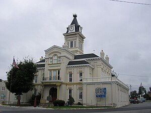
 Adair County Courthouse in Columbia | |
 Location within the U.S. state of Kentucky | |
 Kentucky's location within the U.S. | |
| Coordinates: 37°07′N 85°17′W / 37.11°N 85.28°W | |
| Country | |
| State | |
| Founded | 1801 |
| Named for | John Adair |
| Seat | Columbia |
| Largest city | Columbia |
| Area | |
| • Total | 412 sq mi (1,070 km2) |
| • Land | 405 sq mi (1,050 km2) |
| • Water | 7.1 sq mi (18 km2) 1.7% |
| Population (2020) | |
| • Total | 18,903 |
| • Estimate (2023) | 19,264 |
| • Density | 46/sq mi (18/km2) |
| Time zone | UTC−6 (Central) |
| • Summer (DST) | UTC−5 (CDT) |
| Congressional district | 1st |
| Website | www |
Adair County is a county located in the U.S. state of Kentucky. As of the 2020 census, the population was 18,903.[1] Its county seat and only municipality is Columbia.[2] The county was founded in 1801 and named for John Adair, then Speaker of the House in Kentucky and later Governor of Kentucky (1820 – 1824).[3] Adair County has some of the few surviving American Chestnut trees in the United States.[4][5]
- ^ "State & County QuickFacts". United States Census Bureau. Retrieved February 24, 2023.
- ^ "Find a County". National Association of Counties. Archived from the original on May 31, 2011. Retrieved June 7, 2011.
- ^ Adair County Government (June 6, 2007). "Kentucky: Adair County – Overview". Commonwealth of Kentucky. Archived from the original on March 4, 2016. Retrieved November 10, 2011.
- ^ "State's largest historic Chestnut tree stands on an Adair County farm.", Columbia Magazine, June 17, 2005; Retrieved October 5, 2015.
- ^ Flavell, John. "American tale: Bringing back the perfect tree.", Daily Independent, July 24, 2009.
© MMXXIII Rich X Search. We shall prevail. All rights reserved. Rich X Search