Back مقاطعة آغدام Arabic Ağdam rayonu Azerbaijani آغدام رایونو AZB Агдамскі раён BE-X-OLD Ağdam Breton Districte d'Ağdam Catalan Агдаман кӀошт CE Aghdam Rayon CEB Ağdam (rayon) CRH Ağdam (rajón) Czech
39°59′01″N 46°55′43″E / 39.98361°N 46.92861°E
Aghdam District | |
|---|---|
| Azerbaijani: Ağdam rayonu | |
 | |
 Map of Azerbaijan showing Aghdam District | |
| Country | |
| Region | Karabakh |
| Established | 8 August 1930 |
| Capital | Aghdam |
| Settlements[1] | 138 |
| Government | |
| • Governor | Vagif Hasanov |
| • Special representative | Emin Huseynov[2] |
| Area | |
| • Total | 1,150 km2 (440 sq mi) |
| Population | |
| • Total | 204,000 |
| • Density | 180/km2 (460/sq mi) |
| Time zone | UTC+4 (AZT) |
| Postal code | 0200 |
| Website | agdam-ih |
Aghdam District (Azerbaijani: Ağdam rayonu) is one of the 66 administrative divisions of Azerbaijan. It is located in the west of the country and belongs to the Karabakh Economic Region. The district borders the districts of Khojaly, Kalbajar, Tartar, Khojavend, Aghjabadi, and Barda. Its capital is de jure Aghdam, though the current de facto capital is Quzanlı. As of 2020, the district had a nominal population of 204,000.[3]
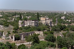
Most of the territory of the district was under the occupation of Armenian forces following the First Nagorno-Karabakh War in the early 1990s. However, as part of the 2020 Nagorno-Karabakh ceasefire agreement which ended the 2020 Nagorno-Karabakh War, the city of Agdam and the surrounding district were returned to Azerbaijani control on 20 November 2020.[4]
- ^ "İnzibati-ərazi vahidləri" (PDF). preslib.az. Retrieved 28 February 2021.
- ^ "Special representative of Azerbaijani President appointed in the liberated part of Aghdam". apa.az. 24 May 2021. Archived from the original on 24 May 2021. Retrieved 9 September 2021.
- ^ a b "Population of Azerbaijan". stat.gov.az. State Statistics Committee. Retrieved 22 February 2021.
- ^ "Azerbaijanis celebrate Karabakh deal". aa.com.tr. Anadolu Agency. 10 November 2020.
© MMXXIII Rich X Search. We shall prevail. All rights reserved. Rich X Search