Back Prefektur Aichi ACE Aichi-prefektuur Afrikaans آيتشي (محافظة) Arabic ايتشى, اليابان ARZ Ayçi prefekturası Azerbaijani آیچی اوستانی AZB Préféktur Aichi BAN Айты (прэфектура) Byelorussian Айчи Bulgarian আইচি প্রশাসনিক অঞ্চল Bengali/Bangla
Aichi Prefecture
愛知県 | |
|---|---|
| Japanese transcription(s) | |
| • Japanese | 愛知県 |
| • Rōmaji | Aichi-ken |
Clockwise from top: | |
| Anthem: Warera ga Aichi | |
 | |
 | |
| Coordinates: 35°10′43″N 136°54′50″E / 35.17861°N 136.91389°E | |
| Country | |
| Region | Chūbu (Tōkai) |
| Island | Honshu |
| Capital | Nagoya |
| Subdivisions | Districts: 7, Municipalities: 54 |
| Government | |
| • Governor | Hideaki Ōmura (since February 2011) |
| Area | |
• Total | 5,172.92 km2 (1,997.28 sq mi) |
| • Rank | 27th |
| Population (1 October 2019) | |
• Total | 7,552,873 |
| • Rank | 4th |
| • Density | 1,500/km2 (3,800/sq mi) |
| GDP | |
| • Total | JP¥ 40,911 billion US$ 375.3 billion (2019) |
| ISO 3166 code | JP-23 |
| Website | www |
| Symbols of Japan | |
| Bird | Oriental scops owl (Otus sunia japonicus) |
| Fish | Kuruma prawn (Penaeus japonicus) |
| Flower | Kakitsubata (Iris laevigata) |
| Tree | Hananoki (Acer pycnanthum) |
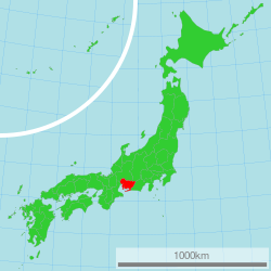
Aichi Prefecture (愛知県, Aichi-ken, Japanese pronunciation: [aꜜi.tɕi, ai.tɕi̥ꜜ.keɴ][2]) is a prefecture of Japan located in the Chūbu region of Honshū.[3]: 11, 126 Aichi Prefecture has a population of 7,461,111 (as of 1 January 2025[update]) and a geographic area of 5,172.92 square kilometres (1,997.28 sq mi) with a population density of 1,442 inhabitants per square kilometre (3,730/sq mi). Aichi Prefecture borders Mie Prefecture to the west, Gifu Prefecture and Nagano Prefecture to the north, and Shizuoka Prefecture to the east. Nagoya is the capital and largest city of the prefecture.
- ^ "2020年度国民経済計算(2015年基準・2008SNA) : 経済社会総合研究所 - 内閣府". 内閣府ホームページ (in Japanese). Archived from the original on 24 September 2023. Retrieved 18 May 2023.
- ^ NHK Broadcasting Culture Research Institute, ed. (24 May 2016). NHK日本語発音アクセント新辞典 (in Japanese). NHK Publishing.
- ^ Cite error: The named reference
Frédéric_2002was invoked but never defined (see the help page).
© MMXXIII Rich X Search. We shall prevail. All rights reserved. Rich X Search


