Back جزيره اكيميسكى ARZ Акимиски Bulgarian Illa Akimiski Catalan Akimiski Island CEB Akimiski Czech Akimiski Island Danish Akimiski Island German Isla Akimiski Spanish Akimiskinsaari Finnish Île Akimiski French
 Closeup of Akimiski Island | |
| Geography | |
|---|---|
| Location | Nunavut |
| Coordinates | 53°00′30″N 081°16′30″W / 53.00833°N 81.27500°W[1] |
| Archipelago | Arctic Archipelago |
| Area | 3,001 km2 (1,159 sq mi) |
| Highest elevation | 34 m (112 ft) |
| Administration | |
Canada | |
| Territory | Nunavut |
| Region | Qikiqtaaluk |
| Demographics | |
| Population | Uninhabited |
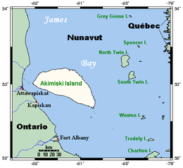
Akimiski Island[1] is the largest island in James Bay (a southeasterly extension of Hudson Bay), Canada, which is part of the Qikiqtaaluk Region of the territory of Nunavut. It has an area of 3,001 km2 (1,159 sq mi), making it the 163rd largest island in the world, and Canada's 29th largest island. Akimiski Island is 19 km (12 mi) from the province of Ontario. From the western side of the island, the Ontario coastline is visible.
The island's name is Swampy Cree[1] for "land across the water".[2]
The island has no year-round human inhabitants. The surface of Akimiski is flat and slopes gradually to the north. Most of the vegetation that covers the island consists of lichen, moss, sedges, and dwarf black spruce. The island is a coastal wetland that includes mudflats, tidal marshes, and tidal mudflats. Freshwater streams that flow into southwestern James Bay carry sediments and abundant nutrients that help to sustain the productive waterfowl habitat around Akimiski Island.
The Akimiski Island Group includes Akimiski, Gasket, and Gullery islands; Albert Shoal; and the Akimiski Strait Isles.
- ^ a b c "Akimiski Island". Geographical Names Data Base. Natural Resources Canada. Retrieved 2020-06-15.
- ^ "Akimiski Island, Nunavut, Canada: An Island in Dispute", Collections Canada
© MMXXIII Rich X Search. We shall prevail. All rights reserved. Rich X Search

