Back شبه جزيرة الفاو Arabic Fao yarımadası Azerbaijani Poloostrov Fao Czech Al-Faw-halvøen Danish Península de Al-Faw Spanish شبهجزیره فاو Persian Penisola di al-Fāw Italian Al-Faw-halvøya NN Al-Faw-halvøya NB Península de Al-Faw Portuguese
This article needs additional citations for verification. (September 2009) |
 | |
 |
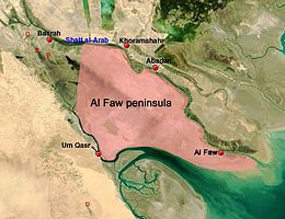
The Al-Faw peninsula (Arabic: شبه جزيرة الفاو; also transliterated as Fao or Fawr) is a peninsula in the Persian Gulf, located in the extreme southeast of Iraq. The marshy peninsula is 20 km (12 mi) southeast of Iraq's third largest city, Basra, and is part of a delta for the Shatt al-Arab (Arvand Rud) river, formed by the confluence of the major Euphrates and Tigris rivers. The al-Faw peninsula borders Iran to the northeast, with the cities of Abadan and Khorramshahr on the opposite side of the Shatt al-Arab, and Kuwait to the southwest, opposite from Bubiyan Island and Warbah Island, near the Iraqi city of Umm Qasr.
Al-Faw, the only significant town on the peninsula and its namesake, is a fishing town and port which during Saddam Hussein's presidency featured the main naval base of the Iraqi Navy. The remainder of the al-Faw peninsula is otherwise lightly inhabited, with few civilian buildings or settlements and most of its few residents involved in the fishing, oil, or shipping industries. It is the site of a number of important oil installations, most notably Iraq's two main oil tanker terminals: Khor al-Amaya and Mina al-Bakr, due to its chief importance as a strategic location controlling access to the Shatt al-Arab waterway and thus access to the port of Basra.
© MMXXIII Rich X Search. We shall prevail. All rights reserved. Rich X Search